
Carte topographique Ranchi
Carte interactive
Cliquez sur la carte pour afficher l’altitude.
À propos de cette carte
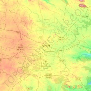
Nom : Carte topographique Ranchi, altitude, relief.
Lieu : Ranchi, Kanke, Ranchi District, Jharkhand, 834001, India (23.21005 85.16504 23.53005 85.48504)
Altitude moyenne : 648 m
Altitude minimum : 458 m
Altitude maximum : 896 m
Ranchi lies at 23°22′N 85°20′E / 23.36°N 85.33°E / 23.36; 85.33 near to the Tropic of Cancer. The city covers an area of 175 km2 (68 sq mi) and its average elevation is 651 m above sea level. Ranchi is located in the southern part of the Chota Nagpur plateau, which is the eastern section of the Deccan plateau.
Autres cartes topographiques
Cliquez sur une carte pour visualiser sa topographie, son altitude et son relief.
Rock Garden
India > Jharkhand > Kanke > Ranchi
Rock Garden, Pahar Gonda, Ranchi, Kanke, Ranchi, Jharkhand, India
Altitude moyenne : 644 m