
Carte topographique Buffalo
Carte interactive
Cliquez sur la carte pour afficher l’altitude.
À propos de cette carte
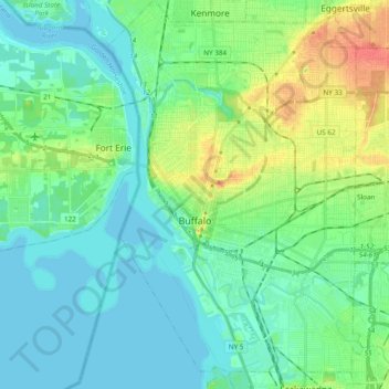
Nom : Carte topographique Buffalo, altitude, relief.
Lieu : Buffalo, Erie County, New York, United States (42.82601 -78.92236 42.96645 -78.79512)
Altitude moyenne : 185 m
Altitude minimum : 172 m
Altitude maximum : 220 m
The Buffalo metropolitan area is on the Erie/Ontario Lake Plain of the Eastern Great Lakes Lowlands, a narrow plain extending east to Utica, New York. The city is generally flat, except for elevation changes in the University Heights and Fruit Belt neighborhoods. The Southtowns are hillier, leading to the Cattaraugus Hills in the Appalachian Upland. Several types of shale, limestone and lagerstätten are prevalent in Buffalo and its surrounding area, lining their stream beds.
Autres cartes topographiques
Cliquez sur une carte pour visualiser sa topographie, son altitude et son relief.
East Aurora
United States > New York > Erie County
East Aurora, Town of Aurora, Erie County, New York, 14052, United States
Altitude moyenne : 283 m
Sandy Beach
United States > New York > Erie County > Town of Grand Island
Sandy Beach, Town of Grand Island, Erie County, New York, 14304, United States
Altitude moyenne : 175 m
Wolcottsburg
United States > New York > Erie County > Town of Clarence
Wolcottsburg, Town of Clarence, Newstead, Erie County, New York, 14032, United States
Altitude moyenne : 180 m
Town of Tonawanda
United States > New York > Erie County
Town of Tonawanda, Erie County, New York, United States
Altitude moyenne : 183 m
South Wales
United States > New York > Erie County
South Wales, Town of Wales, Erie County, New York, 14139, United States
Altitude moyenne : 361 m
Village of Williamsville
United States > New York > Erie County > Town of Amherst
Village of Williamsville, Town of Amherst, Erie County, New York, United States
Altitude moyenne : 206 m
Town of Cheektowaga
United States > New York > Erie County
Town of Cheektowaga, Erie County, New York, United States
Altitude moyenne : 201 m
East Amherst
United States > New York > Erie County > Town of Clarence
East Amherst, Town of Clarence, Erie County, New York, 14051, United States
Altitude moyenne : 183 m
Town of Clarence
United States > New York > Erie County
Town of Clarence, Erie County, New York, United States
Altitude moyenne : 200 m
Town of Amherst
United States > New York > Erie County
Town of Amherst, Erie County, New York, United States
Altitude moyenne : 184 m
Village of Hamburg
United States > New York > Erie County > Town of Hamburg
Village of Hamburg, Town of Hamburg, Erie County, New York, United States
Altitude moyenne : 245 m
Town of Lancaster
United States > New York > Erie County
Town of Lancaster, Erie County, New York, United States
Altitude moyenne : 214 m
Kenilworth
United States > New York > Erie County > Tonawanda Town CDP
Kenilworth, Tonawanda Town CDP, Erie County, New York, 14223, United States
Altitude moyenne : 192 m
Colden
United States > New York > Erie County > Colden
Colden, Town of Colden, Erie County, New York, 14033, United States
Altitude moyenne : 414 m
Orchard Park
United States > New York > Erie County > Orchard Park
Orchard Park, Erie County, New York, 14127, United States
Altitude moyenne : 262 m
Lackawanna
United States > New York > Erie County > Lackawanna
Lackawanna, Erie County, New York, United States
Altitude moyenne : 183 m
Glen Falls
United States > New York > Erie County > Williamsville
Glen Falls, Williamsville, Amherst, Erie County, New York, 14221-5323, United States
Altitude moyenne : 202 m
Ferry Village
United States > New York > Erie County > Ferry Village
Ferry Village, Grand Island, Erie County, New York, 14072, United States
Altitude moyenne : 177 m