
Carte topographique Kolhapur district
Carte interactive
Cliquez sur la carte pour afficher l’altitude.
À propos de cette carte
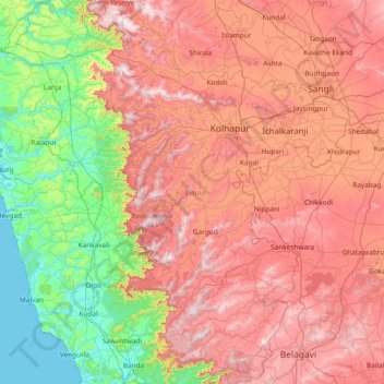
Nom : Carte topographique Kolhapur district, altitude, relief.
Lieu : Kolhapur district, Maharashtra, India (15.74355 73.68728 17.18134 74.70008)
Altitude moyenne : 464 m
Altitude minimum : -2 m
Altitude maximum : 1 056 m
Autres cartes topographiques
Cliquez sur une carte pour visualiser sa topographie, son altitude et son relief.
Pimpri-Chinchwad
India > Maharashtra > Haveli
Pimpri-Chinchwad also known as "PCMC", is a city in the Indian state of Maharashtra. The city is about 15 km (9.3 mi) northwest of the historic city of Pune, at an altitude of 590 m (1,940 ft) above sea level. It is the fifth largest city in Maharashtra and the nineteenth largest city in India and the…
Altitude moyenne : 605 m
Goregaon
India > Maharashtra > Mangaon Taluka
Goregaon is located in the south-west of India at 18°10′N 73°18′E / 18.17°N 73.3°E / 18.17; 73.3. The average elevation is 28 metres (92 ft).
Altitude moyenne : 38 m
Trimbak
India > Maharashtra > Trimbakeshwar
Trimbak is located at 19°34′N 73°19′E / 19.56°N 73.32°E / 19.56; 73.32. It has an average elevation of 720 metres (2362 feet).
Altitude moyenne : 756 m
Pench (Indira Priyadarsini) National Park/Tiger Reserve
India > Maharashtra > Ramtek Taluka
Altitude moyenne : 485 m