
Carte topographique Lucknow
Carte interactive
Cliquez sur la carte pour afficher l’altitude.
À propos de cette carte
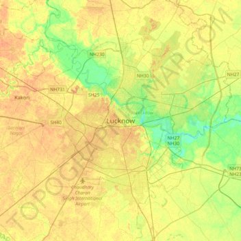
Nom : Carte topographique Lucknow, altitude, relief.
Lieu : Lucknow, Lucknow District, Uttar Pradesh, 226027, India (26.67810 80.77460 26.99810 81.09460)
Altitude moyenne : 120 m
Altitude minimum : 103 m
Altitude maximum : 131 m
The city stands at an elevation of approximately 123 metres (404 ft) above sea level. Lucknow city had an area of 402 km2 (155 square miles) till December 2019, when 88 villages were added to the municipal limits and the area increased to 631 km2 (244 square miles). Bounded on the east by Barabanki, on the west by Unnao, on the south by Raebareli and in the north by Sitapur and Hardoi, Lucknow sits on the northwestern shore of the Gomti River. As of 2008, there were 110 wards in the city. Morphologically, three clear demarcations exist: The Central business district, which is a fully built up area, comprises Hazratganj, Aminabad and Chowk. A middle zone surrounds the inner zone with cement houses while the outer zone consists of slums.
Autres cartes topographiques
Cliquez sur une carte pour visualiser sa topographie, son altitude et son relief.
Vikram Nagar
India > Uttar Pradesh > Lucknow
Vikram Nagar, Lucknow, Lucknow District, Uttar Pradesh, 226008, India
Altitude moyenne : 124 m
Moti Nagar
India > Uttar Pradesh > Lucknow > Lucknow
Moti Nagar, Lucknow, Lucknow District, Uttar Pradesh, 226004, India
Altitude moyenne : 124 m