
Carte topographique New South Wales
Carte interactive
Cliquez sur la carte pour afficher l’altitude.
À propos de cette carte
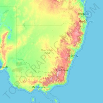
Nom : Carte topographique New South Wales, altitude, relief.
Lieu : New South Wales, Australia (-37.52801 140.99926 -28.14153 159.33903)
Altitude moyenne : 154 m
Altitude minimum : -6 m
Altitude maximum : 2 129 m
The climate in the southern half of the state is generally warm to hot in summer and cool in the winter. The seasons are more defined in the southern half of the state, especially as one moves inland towards South West Slopes, Central West and the Riverina region. The climate in the northeast region of the state, or the North Coast, bordering Queensland, is hot and humid in the summer and mild in winter. The Northern Tablelands, which are also on the North coast, have relatively mild summers and cold winters, due to their high elevation on the Great Dividing Range.
Autres cartes topographiques
Cliquez sur une carte pour visualiser sa topographie, son altitude et son relief.
Oberon Council
Oberon Council, New South Wales, 2787, Australia
Altitude moyenne : 899 m
Sydney
Sydney, Council of the City of Sydney, New South Wales, Australia
Altitude moyenne : 53 m
Daintree Rainforest
Daintree Rainforest, Diwan, Douglas Shire, Queensland, Australia
Altitude moyenne : 59 m
Maryvale
Maryvale, Southern Downs Regional, Queensland, Australia
Altitude moyenne : 654 m
Willow Grove
Willow Grove, Shire of Baw Baw, Victoria, 3825, Australia
Altitude moyenne : 152 m
Regentville
Australia > New South Wales > Sydney
Regentville, Sydney, Penrith City Council, New South Wales, 2745, Australia
Altitude moyenne : 37 m
Shire of Corangamite
Shire of Corangamite, Victoria, Australia
Altitude moyenne : 151 m
Somersby
Australia > New South Wales > Gosford
Somersby, Gosford, Central Coast Council, New South Wales, 2250, Australia
Altitude moyenne : 151 m
Cherry Creek
Cherry Creek, Toowoomba Regional, Queensland, Australia
Altitude moyenne : 414 m
Kogan
Kogan, Western Downs Regional, Queensland, Australia
Altitude moyenne : 344 m
Cushnie
Cushnie, South Burnett Regional, Queensland, Australia
Altitude moyenne : 426 m
West End
West End, Greater Brisbane, Queensland, 4101, Australia
Altitude moyenne : 15 m
Davies Park
Davies Park, West End, Greater Brisbane, Queensland, 4101, Australia
Altitude moyenne : 16 m
Abergowrie
Abergowrie, Hinchinbrook Shire, Queensland, Australia
Altitude moyenne : 270 m
Richmond
Australia > South Australia > Adelaide
Richmond, Adelaide, City of West Torrens, South Australia, 5033, Australia
Altitude moyenne : 18 m
Anderleigh
Anderleigh, Gympie Regional, Queensland, Australia
Altitude moyenne : 121 m
North Perth
North Perth, City Of Vincent, Western Australia, 6006, Australia
Altitude moyenne : 31 m
Nambung
Nambung, Shire Of Dandaragan, Western Australia, Australia
Altitude moyenne : 60 m
Bringelly
Australia > New South Wales > Sydney
Bringelly, Sydney, Liverpool City Council, New South Wales, 2556, Australia
Altitude moyenne : 87 m
Norries Headland
Norries Headland, Cabarita Hill Walking Track, Cabarita Beach, Tweed Shire Council, New South Wales, 2488, Australia
Altitude moyenne : 2 m
Mount Bartle Frere (South Peak)
Mount Bartle Frere (South Peak), Cairns Regional, Queensland, Australia
Altitude moyenne : 1 276 m
Kosciuszko
Kosciuszko, Snowy Valleys Council, New South Wales, 2627, Australia
Altitude moyenne : 1 434 m
Hindmarsh Tiers
Australia > South Australia > City of Victor Harbor
Hindmarsh Tiers, City of Victor Harbor, South Australia, 5202, Australia
Altitude moyenne : 297 m
Oyster Bay
Australia > New South Wales > Sydney
Oyster Bay, Sutherland Shire, Sydney, Sutherland Shire Council, New South Wales, 2225, Australia
Altitude moyenne : 25 m
Greenvale
Greenvale, Charters Towers Regional, Queensland, Australia
Altitude moyenne : 545 m
Wollondilly River
Wollondilly River, New South Wales, Australia
Altitude moyenne : 691 m
Nambucca Heads
Nambucca Heads, Nambucca Valley Council, New South Wales, 2448, Australia
Altitude moyenne : 16 m
Louth
Australia > New South Wales > Bourke Shire Council
Louth, Bourke Shire Council, New South Wales, 2840, Australia
Altitude moyenne : 124 m
Muttaburra
Muttaburra, Barcaldine Regional, Queensland, 4732, Australia
Altitude moyenne : 240 m
Irvinebank
Irvinebank, Mareeba Shire, Queensland, Australia
Altitude moyenne : 710 m
Ormeau
Australia > Queensland > Gold Coast City
Ormeau, Gold Coast City, Queensland, 4208, Australia
Altitude moyenne : 24 m
Coronet Bay
Australia > Victoria > Coronet Bay
Coronet Bay, Bass Coast Shire, Victoria, 3984, Australia
Altitude moyenne : 13 m
Goulds Country
Goulds Country, Break O'Day, Tasmania, 7216, Australia
Altitude moyenne : 308 m
Gum Swamp, Miepol Wildlife Reserve (no hunting)
Gum Swamp, Miepol Wildlife Reserve (no hunting), Miepoll, Shire of Strathbogie, Victoria, Australia
Altitude moyenne : 139 m
Lake Wyangan
Australia > New South Wales > Griffith City Council
Lake Wyangan, Griffith City Council, New South Wales, 2680, Australia
Altitude moyenne : 122 m
Kully Bay
Australia > New South Wales > Wollongong City Council
Kully Bay, Wollongong City Council, New South Wales, 2502, Australia
Altitude moyenne : 13 m
Guilderton
Guilderton, Shire Of Gingin, Western Australia, Australia
Altitude moyenne : 25 m
Golden Grove
Australia > South Australia > Adelaide
Golden Grove, Adelaide, City of Tea Tree Gully, South Australia, 5125, Australia
Altitude moyenne : 215 m
Lewisham
Australia > New South Wales > Sydney
Lewisham, Inner West, Sydney, Inner West Council, New South Wales, 2049, Australia
Altitude moyenne : 28 m
City of Victor Harbor
City of Victor Harbor, South Australia, 5211, Australia
Altitude moyenne : 148 m
Echo Point Lookout
Australia > New South Wales > Limpinwood
Echo Point Lookout, Albert River Circuit, Limpinwood, O'Reilly, Tweed Shire Council, New South Wales, Australia
Altitude moyenne : 774 m