
Carte topographique Kanyakumari
Carte interactive
Cliquez sur la carte pour afficher l’altitude.
À propos de cette carte
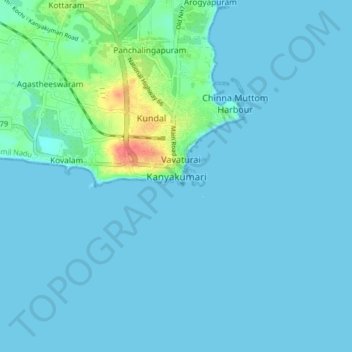
Nom : Carte topographique Kanyakumari, altitude, relief.
Altitude moyenne : 6 m
Altitude minimum : 0 m
Altitude maximum : 55 m
Kanniyakumari is located at 8°05′N 77°34′E / 8.08°N 77.57°E / 8.08; 77.57. and has an average elevation of 30 metres. The peninsular tip of Kanniyakumari is bordered on three sides by the Laccadive Sea. It is located at the confluence of the Western Coastal Plains and Eastern Coastal Plains.
Autres cartes topographiques
Cliquez sur une carte pour visualiser sa topographie, son altitude et son relief.
Manakudy
India > Tamil Nadu > Agastheeswaram
Manakudy, Agastheeswaram, Kanniyakumari District, Tamil Nadu, 629602, India
Altitude moyenne : 6 m
Karavilai
India > Tamil Nadu > Agastheeswaram
Karavilai, Agastheeswaram, Kanniyakumari District, Tamil Nadu, 629503, India
Altitude moyenne : 28 m
Nagercoil
India > Tamil Nadu > Agastheeswaram
Nagercoil, Agastheeswaram, Kanniyakumari District, Tamil Nadu, 629001, India
Altitude moyenne : 83 m