
Carte topographique Khyber Pakhtunkhwa
Carte interactive
Cliquez sur la carte pour afficher l’altitude.
À propos de cette carte
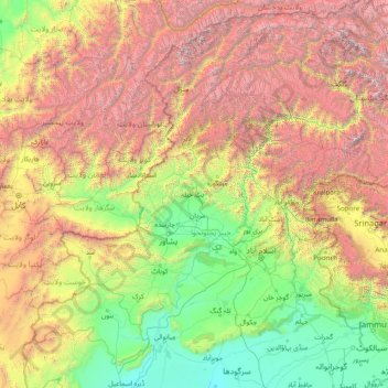
Nom : Carte topographique Khyber Pakhtunkhwa, altitude, relief.
Lieu : Khyber Pakhtunkhwa, Pakistan (31.94000 69.44000 37.06000 74.56000)
Altitude moyenne : 2 135 m
Altitude minimum : 170 m
Altitude maximum : 7 856 m
Autres cartes topographiques
Cliquez sur une carte pour visualiser sa topographie, son altitude et son relief.
Nowshak
Nowshak, Chitrāl District, Khyber Pakhtunkhwa, Pakistan
Altitude moyenne : 6 863 m
Tirich Mir
Tirich Mir, Chitrāl District, Khyber Pakhtunkhwa, Pakistan
Altitude moyenne : 6 886 m
Istor-o-Nal
Istor-o-Nal, Chitrāl District, Khyber Pakhtunkhwa, Pakistan
Altitude moyenne : 6 853 m
Chitrâl
Pakistan > Khyber Pakhtunkhwa > Chitrâl
Chitrâl, Chitrāl District, Khyber Pakhtunkhwa, Pakistan
Altitude moyenne : 2 047 m