
Carte topographique Byram cum Sutton
Carte interactive
Cliquez sur la carte pour afficher l’altitude.
À propos de cette carte
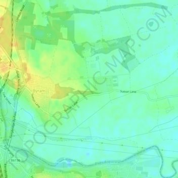
Nom : Carte topographique Byram cum Sutton, altitude, relief.
Altitude moyenne : 13 m
Altitude minimum : 3 m
Altitude maximum : 29 m
Autres cartes topographiques
Cliquez sur une carte pour visualiser sa topographie, son altitude et son relief.
Saxton
United Kingdom > England > Selby > Saxton
Saxton, Selby, North Yorkshire, Yorkshire and the Humber, England, LS24 9PZ, United Kingdom
Altitude moyenne : 32 m
Brotherton
United Kingdom > England > Selby > Brotherton
Brotherton, Selby, North Yorkshire, Yorkshire and the Humber, England, United Kingdom
Altitude moyenne : 16 m
Carlton
United Kingdom > England > Selby > Carlton
Carlton, Selby, North Yorkshire, Yorkshire and the Humber, England, DN14 9PB, United Kingdom
Altitude moyenne : 5 m
Hemingbrough
United Kingdom > England > Selby
Hemingbrough, Selby, North Yorkshire, Yorkshire and the Humber, England, United Kingdom
Altitude moyenne : 5 m
Carlton
United Kingdom > England > Selby
Carlton, Selby, North Yorkshire, Yorkshire and the Humber, England, United Kingdom
Altitude moyenne : 6 m
Beal
United Kingdom > England > Selby
Beal, Selby, North Yorkshire, Yorkshire and the Humber, England, United Kingdom
Altitude moyenne : 10 m
Brayton
United Kingdom > England > Selby
Brayton, Selby, North Yorkshire, Yorkshire and the Humber, England, United Kingdom
Altitude moyenne : 8 m
Camblesforth
United Kingdom > England > Selby
Camblesforth, Selby, North Yorkshire, Yorkshire and the Humber, England, United Kingdom
Altitude moyenne : 6 m
Kellington
United Kingdom > England > Selby
Kellington, Selby, North Yorkshire, Yorkshire and the Humber, England, United Kingdom
Altitude moyenne : 11 m