
Carte topographique Anand
Carte interactive
Cliquez sur la carte pour afficher l’altitude.
À propos de cette carte
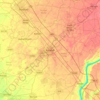
Nom : Carte topographique Anand, altitude, relief.
Lieu : Anand, Anand Taluka, Anand District, Gujarat, 388001, India (22.39866 72.80272 22.71866 73.12272)
Altitude moyenne : 40 m
Altitude minimum : 4 m
Altitude maximum : 59 m
Anand is located at 22°34′N 72°56′E / 22.57°N 72.93°E / 22.57; 72.93. It has an average elevation of 39 m (128 ft). The city has an area of 22.7 km2 (8.8 sq mi).