
Carte topographique Machilipatnam
Carte interactive
Cliquez sur la carte pour afficher l’altitude.
À propos de cette carte
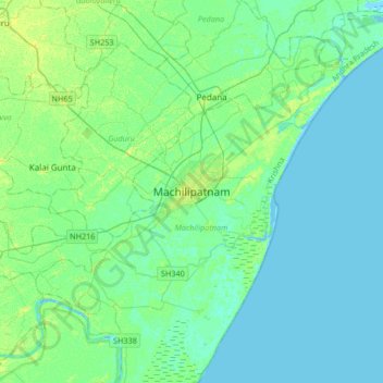
Nom : Carte topographique Machilipatnam, altitude, relief.
Lieu : Machilipatnam, Krishna, Andhra Pradesh, 521001, India (16.02174 80.97482 16.34174 81.29482)
Altitude moyenne : 4 m
Altitude minimum : -4 m
Altitude maximum : 13 m
Machilipatnam city is at 16°10′N 81°08′E / 16.17°N 81.13°E / 16.17; 81.13 on the southeast coast of India and in the east coast of Andhra Pradesh. The city has an average elevation of 14 meters (45 feet).