
Carte topographique Big Bear Lake
Carte interactive
Cliquez sur la carte pour afficher l’altitude.
À propos de cette carte
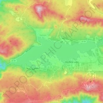
Nom : Carte topographique Big Bear Lake, altitude, relief.
Altitude moyenne : 2 209 m
Altitude minimum : 1 905 m
Altitude maximum : 2 544 m
At a surface elevation of 6,743 ft (2,055 m) above sea level, it has an east-west length of approximately seven miles (11 km) and is approximately 2.5 miles (4.0 km) at its widest measurement, though the lake's width mostly averages a little more than 1⁄2 mi (0.8 km). These approximations are based on the lake having an optimum retainable water level. At dam's end, Big Bear measures its deepest water at 72 feet (22 m).
Autres cartes topographiques
Cliquez sur une carte pour visualiser sa topographie, son altitude et son relief.
Moonridge
United States > California > San Bernardino County > Big Bear Lake
Moonridge, Big Bear Lake, San Bernardino County, CAL Fire Southern Region, California, 92314, United States
Altitude moyenne : 2 211 m