
Carte topographique Uttar Pradesh
Carte interactive
Cliquez sur la carte pour afficher l’altitude.
À propos de cette carte
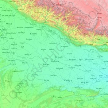
Nom : Carte topographique Uttar Pradesh, altitude, relief.
Lieu : Uttar Pradesh, India (23.87063 77.08388 30.40638 84.63451)
Altitude moyenne : 954 m
Altitude minimum : 47 m
Altitude maximum : 7 878 m
Uttar Pradesh, with a total area of 243,290 square kilometres (93,935 sq mi), is India's fourth-largest state in terms of land area and is roughly of same size as United Kingdom. It is situated on the northern spout of India and shares an international boundary with Nepal. The Himalayas border the state on the north, but the plains that cover most of the state are distinctly different from those high mountains. The larger Gangetic Plain region is in the north; it includes the Ganges-Yamuna Doab, the Ghaghra plains, the Ganges plains and the Terai. The smaller Vindhya Range and plateau region are in the south. It is characterised by hard rock strata and a varied topography of hills, plains, valleys and plateaus. The Bhabhar tract gives place to the terai area which is covered with tall elephant grass and thick forests interspersed with marshes and swamps. The sluggish rivers of the bhabhar deepen in this area, their course running through a tangled mass of thick undergrowth. The terai runs parallel to the bhabhar in a thin strip. The entire alluvial plain is divided into three sub-regions. The first in the eastern tract consisting of 14 districts which are subject to periodical floods and droughts and have been classified as scarcity areas. These districts have the highest density of population which gives the lowest per capita land. The other two regions, the central and the western, are comparatively better with a well-developed irrigation system. They suffer from waterlogging and large-scale user tracts. In addition, the area is fairly arid. The state has more than 32 large and small rivers; of them, the Ganga, Yamuna, Saraswati, Sarayu, Betwa, and Ghaghara are larger and of religious importance in Hinduism.
Autres cartes topographiques
Cliquez sur une carte pour visualiser sa topographie, son altitude et son relief.
Bengaluru
India > Karnataka > Bangalore North
Bengaluru, Bangalore North, Bengaluru Urban District, Karnataka, India
Altitude moyenne : 881 m
Chennai
India > Tamil Nadu > Chennai
Chennai, Chennai District, Tamil Nadu, India
Altitude moyenne : 8 m
3d
India > Rajasthan > Ganganagar Tehsil > 1 LNP
3d, 1 LNP, Ganganagar Tehsil, Sri Ganganagar District, Rajasthan, India
Altitude moyenne : 178 m
Pune
India > Maharashtra > Pune City > Pune
Pune, Pune City, Pune District, Maharashtra, 411001, India
Altitude moyenne : 641 m
Dholka
India > Madhya Pradesh > Ratlam Tahsil
Dholka, Ratlam Tahsil, Ratlam District, Madhya Pradesh, India
Altitude moyenne : 467 m
musi
India > Telangana > Balanagar mandal > Hyderabad
musi, Greater Hyderabad Municipal Corporation North Zone, Hyderabad, Balanagar mandal, Medchal–Malkajgiri District, Telangana, India
Altitude moyenne : 524 m
Manapparai
India > Tamil Nadu > Manapparai
Manapparai, Tiruchirappalli District, Tamil Nadu, 621306, India
Altitude moyenne : 161 m
Tehri-Garhwal
Tehri-Garhwal, Tehri Garhwal District, Uttarakhand, 249125, India
Altitude moyenne : 2 339 m
Kolkata
Kolkata, Kolkata District, West Bengal, 700073, India
Altitude moyenne : 5 m
Harapanahalli
India > Karnataka > Harapanahalli taluku
Harapanahalli, Harapanahalli taluku, Vijayanagara District, Karnataka, 583131, India
Altitude moyenne : 626 m
Kwatha Meitei
India > Manipur > Tengnoupal tehsil
Kwatha Meitei, Tengnoupal tehsil, Tengnoupal District, Manipur, India
Altitude moyenne : 476 m
Sengarai
India > Tamil Nadu > KOLLI HILLS
Sengarai, KOLLI HILLS, Namakkal District, Tamil Nadu, 637411, India
Altitude moyenne : 1 060 m
Anaikkattu
India > Tamil Nadu > Vellore
Anaikkattu, Vellore, Vellore District, Tamil Nadu, 632101, India
Altitude moyenne : 272 m
Gudiyatham
India > Tamil Nadu > Gudiyatham
Gudiyatham, Vellore District, Tamil Nadu, 635803, India
Altitude moyenne : 294 m
Pernampattu
India > Tamil Nadu > Gudiyatham
Pernampattu, Gudiyatham, Vellore District, Tamil Nadu, 635810, India
Altitude moyenne : 425 m
Arasur
India > Tamil Nadu > Thiruvennainallur
Arasur, Thiruvennainallur, Viluppuram District, Tamil Nadu, India
Altitude moyenne : 51 m
Thandrampet
Thandrampet, Tiruvannamalai District, Tamil Nadu, India
Altitude moyenne : 258 m
Vaniyambadi
Vaniyambadi, Tirupattur District, Tamil Nadu, India
Altitude moyenne : 559 m
Natrampalli
India > Tamil Nadu > Tirupathur
Natrampalli, Tirupathur, Tirupattur District, Tamil Nadu, 635852, India
Altitude moyenne : 438 m
Pandarapuram
India > Tamil Nadu > Sathankulam
Pandarapuram, Sathankulam, Thoothukudi District, Tamil Nadu, 628704, India
Altitude moyenne : 35 m
Marungapuri
India > Tamil Nadu > Manapparai
Marungapuri, Manapparai, Tiruchirappalli District, Tamil Nadu, India
Altitude moyenne : 249 m
Periyar River
India > Kerala > Paravur > Edayar
Periyar River, Njaarakkaattu, Edayar, Paravur, Ernakulam District, Kerala, India
Altitude moyenne : 8 m
Rampur
India > Odisha > Madanpur Rampur
Rampur, Madanpur Rampur, Kalahandi District, Odisha, 766112, India
Altitude moyenne : 211 m
Nanded
India > Maharashtra > Nanded
Nanded, Nanded District, Maharashtra, 431600, India
Altitude moyenne : 376 m