
Carte topographique Lake Seed
Carte interactive
Cliquez sur la carte pour afficher l’altitude.
À propos de cette carte
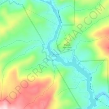
Nom : Carte topographique Lake Seed, altitude, relief.
Lieu : Lake Seed, Rabun County, Georgia, United States (34.75154 -83.52324 34.79016 -83.50066)
Altitude moyenne : 653 m
Altitude minimum : 516 m
Altitude maximum : 896 m
Autres cartes topographiques
Cliquez sur une carte pour visualiser sa topographie, son altitude et son relief.
Mountain City
United States > Georgia > Rabun County
Mountain City, Rabun County, Georgia, 30562, United States
Altitude moyenne : 747 m
Chestnut Mountain
United States > Georgia > Rabun County
Chestnut Mountain, Rabun County, Georgia, 30537, United States
Altitude moyenne : 834 m
Clayton
United States > Georgia > Rabun County
Clayton, Rabun County, Georgia, 30525, United States
Altitude moyenne : 621 m
Sky Valley
United States > Georgia > Rabun County
Sky Valley, Rabun County, Georgia, 30537, United States
Altitude moyenne : 973 m
Elisha Mountain
United States > Georgia > Rabun County
Elisha Mountain, Rabun County, Georgia, 30525, United States
Altitude moyenne : 828 m
Blalock
United States > Georgia > Rabun County
Blalock, Rabun County, Georgia, United States
Altitude moyenne : 682 m
Lake Burton
United States > Georgia > Rabun County
Lake Burton, Rabun County, Georgia, United States
Altitude moyenne : 662 m
Black Rock Mountain State Park
United States > Georgia > Rabun County > Mountain City
Black Rock Mountain State Park, Mountain City, Rabun County, Georgia, United States
Altitude moyenne : 833 m
Tallulah Gorge State Park
United States > Georgia > Rabun County > Tallulah Falls
Tallulah Gorge State Park, Tallulah Falls, Rabun County, Georgia, United States
Altitude moyenne : 435 m
Tallulah Gorge
United States > Georgia > Rabun County > Tallulah Falls
Tallulah Gorge, Tallulah Falls, Rabun County, Georgia, United States
Altitude moyenne : 465 m
Lakemont
United States > Georgia > Rabun County
Lakemont, Rabun County, Georgia, 30581, United States
Altitude moyenne : 547 m
Dillard
United States > Georgia > Rabun County
Dillard, Rabun County, Georgia, United States
Altitude moyenne : 691 m
Rabun Gap Nacoochee School Lake
United States > Georgia > Rabun County
Rabun Gap Nacoochee School Lake, Rabun County, Georgia, United States
Altitude moyenne : 671 m
Ben Mountain
United States > Georgia > Rabun County
Ben Mountain, Rabun County, Georgia, 30537, United States
Altitude moyenne : 866 m
Rabun Gap Nacoochee School Lake Dam
United States > Georgia > Rabun County
Rabun Gap Nacoochee School Lake Dam, Rabun County, Georgia, 30568, United States
Altitude moyenne : 671 m