
Carte topographique The Woodlands
Carte interactive
Cliquez sur la carte pour afficher l’altitude.
À propos de cette carte
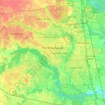
Nom : Carte topographique The Woodlands, altitude, relief.
Lieu : The Woodlands, Montgomery County, Texas, United States (30.10304 -95.60120 30.23057 -95.43430)
Altitude moyenne : 47 m
Altitude minimum : 23 m
Altitude maximum : 72 m
The Woodlands is in a heavily forested area, and much of the community has retained trees for shade and decoration. The terrain is essentially flat, with the exception of topographic variations ranging from 125 to 175 feet above sea level between Spring Creek and Flintridge Drive.
Autres cartes topographiques
Cliquez sur une carte pour visualiser sa topographie, son altitude et son relief.
Security
United States > Texas > Montgomery County
Security, Montgomery County, Texas, United States
Altitude moyenne : 53 m
The Falls at Imperial Oaks
United States > Texas > Montgomery County
The Falls at Imperial Oaks, Montgomery County, Texas, United States
Altitude moyenne : 32 m
LITTLE LAKE CONROE
United States > Texas > Montgomery County > Conroe
LITTLE LAKE CONROE, Conroe, Montgomery County, Texas, United States
Altitude moyenne : 77 m
Benders Landing
United States > Texas > Montgomery County
Benders Landing, Montgomery County, Texas, United States
Altitude moyenne : 29 m
Porter
United States > Texas > Montgomery County
Porter, Montgomery County, Texas, 77365, United States
Altitude moyenne : 30 m
Alden Bridge
United States > Texas > Montgomery County > The Woodlands
Alden Bridge, The Woodlands, Montgomery County, Texas, 77382, United States
Altitude moyenne : 55 m
Magnolia
United States > Texas > Montgomery County
Magnolia, Montgomery County, Texas, United States
Altitude moyenne : 77 m
New Caney
United States > Texas > Montgomery County
New Caney, Montgomery County, Texas, 77357, United States
Altitude moyenne : 30 m
Lake Egypt
United States > Texas > Montgomery County > Egypt
Lake Egypt, Laurelwoode, Egypt, Montgomery County, Texas, United States
Altitude moyenne : 61 m
Conroe
United States > Texas > Montgomery County > Conroe > Conroe
Conroe, Montgomery County, Texas, 77301, United States
Altitude moyenne : 60 m
Panther Creek
United States > Texas > Montgomery County > The Woodlands
Panther Creek, The Woodlands, Montgomery County, Texas, United States
Altitude moyenne : 47 m
Willis
United States > Texas > Montgomery County
Willis, Montgomery County, Texas, 77305, United States
Altitude moyenne : 99 m
Conroe
United States > Texas > Montgomery County
Conroe, Montgomery County, Texas, United States
Altitude moyenne : 62 m
Sterling Ridge
United States > Texas > Montgomery County > The Woodlands
Sterling Ridge, The Woodlands, Montgomery County, Texas, United States
Altitude moyenne : 55 m