
Carte topographique Sugar Land
Carte interactive
Cliquez sur la carte pour afficher l’altitude.
À propos de cette carte
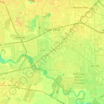
Nom : Carte topographique Sugar Land, altitude, relief.
Lieu : Sugar Land, Fort Bend County, Texas, United States (29.51252 -95.69811 29.66187 -95.58050)
Altitude moyenne : 24 m
Altitude minimum : 8 m
Altitude maximum : 33 m
Sugar Land is located in northeast Fort Bend County, 20 miles (32 km) southwest of downtown Houston. It is bordered by Houston to the northeast, and by Stafford, Missouri City, and Meadows Place to the east. According to the United States Census Bureau, the city of Sugar Land has a total area of 34.0 square miles (88.1 km2), of which 32.4 square miles (83.9 km2) are land and 1.6 square miles (4.2 km2), or 4.82%, are covered by water. The elevation of most of the city is between 70 and 90 feet (21 and 27 m) above sea level. The elevation of Sugar Land Regional Airport (SGR) is 82 feet (25 m).
Autres cartes topographiques
Cliquez sur une carte pour visualiser sa topographie, son altitude et son relief.
Katy
United States > Texas > Fort Bend County
Katy, Fort Bend County, Texas, United States
Altitude moyenne : 44 m
Fulshear
United States > Texas > Fort Bend County
Fulshear, Fort Bend County, Texas, United States
Altitude moyenne : 37 m
Missouri City
United States > Texas > Fort Bend County
Missouri City, Fort Bend County, Texas, United States
Altitude moyenne : 22 m
Thompsons
United States > Texas > Fort Bend County
Thompsons, Fort Bend County, Texas, United States
Altitude moyenne : 22 m
Mission Bend
United States > Texas > Fort Bend County
Mission Bend, Fort Bend County, Texas, 77083, United States
Altitude moyenne : 29 m
Palmetto
United States > Texas > Fort Bend County
Palmetto, Fort Bend County, Texas, 77545, United States
Altitude moyenne : 22 m
Sienna (Brazos River) Park
United States > Texas > Fort Bend County > Missouri City
Sienna (Brazos River) Park, Missouri City, Fort Bend County, Texas, 77459, United States
Altitude moyenne : 20 m
Sienna
United States > Texas > Fort Bend County > Sienna
Sienna, Fort Bend County, Texas, 77583, United States
Altitude moyenne : 20 m
Thompsons
United States > Texas > Fort Bend County > Thompsons
Thompsons, Fort Bend County, Texas, 77481, United States
Altitude moyenne : 20 m
Oak Hill
United States > Texas > Fort Bend County
Oak Hill, Fort Bend County, Texas, 77406, United States
Altitude moyenne : 29 m
Sugar Land
United States > Texas > Fort Bend County > Sugar Land
Sugar Land, Fort Bend County, Texas, 77478, United States
Altitude moyenne : 25 m
Duke
United States > Texas > Fort Bend County > Arcola
Duke, Arcola, Fort Bend County, Texas, 77545, United States
Altitude moyenne : 20 m
Rosenberg
United States > Texas > Fort Bend County
Rosenberg, Fort Bend County, Texas, 77471, United States
Altitude moyenne : 28 m
Orchard
United States > Texas > Fort Bend County
Orchard, Fort Bend County, Texas, 77464, United States
Altitude moyenne : 38 m
Richmond
United States > Texas > Fort Bend County
Richmond, Fort Bend County, Texas, 44769, United States
Altitude moyenne : 27 m
Stafford
United States > Texas > Fort Bend County
Stafford, Fort Bend County, Texas, 77477, United States
Altitude moyenne : 25 m
Fresno
United States > Texas > Fort Bend County
Fresno, Fort Bend County, Texas, 77545, United States
Altitude moyenne : 21 m
Needville
United States > Texas > Fort Bend County
Needville, Fort Bend County, Texas, United States
Altitude moyenne : 28 m
Weston Lakes
United States > Texas > Fort Bend County > Weston Lakes
Weston Lakes, Fort Bend County, Texas, United States
Altitude moyenne : 34 m
Pecan Grove
United States > Texas > Fort Bend County
Pecan Grove, Fort Bend County, Texas, 77496, United States
Altitude moyenne : 27 m
Simonton
United States > Texas > Fort Bend County
Simonton, Fort Bend County, Texas, United States
Altitude moyenne : 35 m
Arcola
United States > Texas > Fort Bend County
Arcola, Fort Bend County, Texas, United States
Altitude moyenne : 20 m