
Carte topographique Cuddalore
Carte interactive
Cliquez sur la carte pour afficher l’altitude.
Cuddalore
Cuddalore is located at 11°45′N 79°45′E / 11.75°N 79.75°E / 11.75; 79.75. It has an average elevation of 6 m (20 ft). The land is completely flat with large black and alluvial soil inland and coarse sand near the seashore. The sandstone deposits in the town are popular. The Pennayar River runs north of the town, while Gadilam River runs across it. Cuddalore is situated at 200 km (120 mi) from the state capital Chennai and 18 km (11 mi) from Puducherry, the neighbouring union territory.
À propos de cette carte
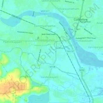
Nom : Carte topographique Cuddalore, altitude, relief.
Lieu : Cuddalore, Cuddalore District, Tamil Nadu, 607002, India (11.72623 79.72313 11.75814 79.76974)
Altitude moyenne : 8 m
Altitude minimum : -1 m
Altitude maximum : 32 m
Autres cartes topographiques
Cliquez sur une carte pour visualiser sa topographie, son altitude et son relief.
Cuddalore
India > Tamil Nadu > Cuddalore
Cuddalore is located at 11°45′N 79°45′E / 11.75°N 79.75°E / 11.75; 79.75. It has an average elevation of 6 m (20 ft). The land is completely flat with large black and alluvial soil inland and coarse sand near the seashore. The sandstone deposits in the town are popular. The Pennayar River runs north of…
Altitude moyenne : 11 m