
Carte topographique City of London
Carte interactive
Cliquez sur la carte pour afficher l’altitude.
À propos de cette carte
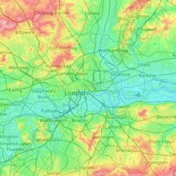
Nom : Carte topographique City of London, altitude, relief.
Lieu : City of London, England, EC2V 5AE, United Kingdom (51.35562 -0.25200 51.67562 0.06800)
Altitude moyenne : 42 m
Altitude minimum : -3 m
Altitude maximum : 166 m
The elevation of the City ranges from sea level at the Thames to 21.6 metres (71 ft) at the junction of High Holborn and Chancery Lane. Two small but notable hills are within the historic core, Ludgate Hill to the west and Cornhill to the east. Between them ran the Walbrook, one of the many "lost" rivers or streams of London (another is the Fleet).