
Carte topographique Central Ridge Reserve Forest
Carte interactive
Cliquez sur la carte pour afficher l’altitude.
À propos de cette carte
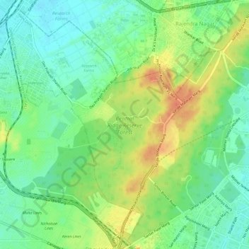
Nom : Carte topographique Central Ridge Reserve Forest, altitude, relief.
Altitude moyenne : 235 m
Altitude minimum : 216 m
Altitude maximum : 261 m
Autres cartes topographiques
Cliquez sur une carte pour visualiser sa topographie, son altitude et son relief.
Ramakrishna Puram
Ramakrishna Puram, Vasant Vihar Tehsil, New Delhi, Delhi, India
Altitude moyenne : 235 m
Vasant Kunj
Vasant Kunj, Vasant Vihar Tehsil, New Delhi, Delhi, India
Altitude moyenne : 261 m
Chanakyapuri
Chanakyapuri, Chanakya Puri Tehsil, New Delhi, Delhi, 110021, India
Altitude moyenne : 228 m
Vasant Vihar
Vasant Vihar, Delhi Cantonment, New Delhi, Delhi, 110057, India
Altitude moyenne : 244 m
Lodhi Gardens
Lodhi Gardens, Rabindra Nagar, New Delhi, Chanakya Puri Tehsil, Delhi, India
Altitude moyenne : 214 m