
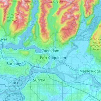
Carte topographique Coquitlam
Carte interactive
Cliquez sur la carte pour afficher l’altitude.
À propos de cette carte
Nom : Carte topographique Coquitlam, altitude, relief.
Altitude moyenne : 230 m
Altitude minimum : -4 m
Altitude maximum : 1 532 m
Southwest Coquitlam comprises the original core of the city, with Maillardville and Fraser River industrial sector giving way to the large residential areas of Austin Heights, colloquially referred to as "The Bump" due to its high and flat plateau topography. These older residences, with larger property dimensions, are increasingly being torn down and replaced with newer and larger homes. The Poirier Street area was the city's original recreational centre with the Coquitlam Sports Centre, Chimo Aquatic and Fitness Centre, and sports fields located there, while City Hall was previously located further south in Maillardville.
Autres cartes topographiques
Cliquez sur une carte pour visualiser sa topographie, son altitude et son relief.
Town Centre Park
Canada > British Columbia > Metro Vancouver Regional District > Coquitlam
Town Centre Park, River Springs, Coquitlam, Metro Vancouver Regional District, British Columbia, Canada
Altitude moyenne : 62 m
Mundy Park
Canada > British Columbia > Metro Vancouver Regional District > Coquitlam
Mundy Park, River Heights, Coquitlam, Metro Vancouver Regional District, British Columbia, Canada
Altitude moyenne : 139 m