
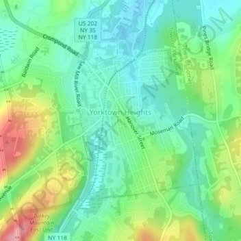
Carte topographique Yorktown Heights
Carte interactive
Cliquez sur la carte pour afficher l’altitude.
À propos de cette carte
Nom : Carte topographique Yorktown Heights, altitude, relief.
Altitude moyenne : 159 m
Altitude minimum : 117 m
Altitude maximum : 246 m
Autres cartes topographiques
Cliquez sur une carte pour visualiser sa topographie, son altitude et son relief.
Lake Mohansic
United States > New York > Westchester County > Town of Yorktown
Lake Mohansic, Town of Yorktown, Westchester County, New York, United States
Altitude moyenne : 159 m
Lake Mohegan
United States > New York > Westchester County > Town of Yorktown
Lake Mohegan, Town of Yorktown, Westchester County, New York, 10547, United States
Altitude moyenne : 140 m
Shrub Oak
United States > New York > Westchester County > Town of Yorktown
Shrub Oak, Town of Yorktown, Westchester County, New York, 10588, United States
Altitude moyenne : 156 m
Turkey Mountain
United States > New York > Westchester County > Town of Yorktown
Turkey Mountain, Town of Yorktown, Westchester County, New York, United States
Altitude moyenne : 142 m