
Carte topographique Godavari
Carte interactive
Cliquez sur la carte pour afficher l’altitude.
À propos de cette carte
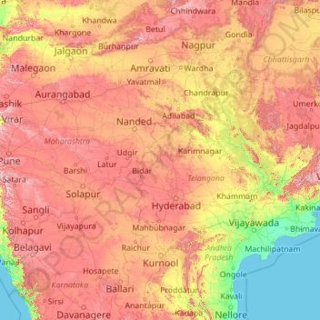
Nom : Carte topographique Godavari, altitude, relief.
Lieu : Godavari, Nizamabad, Telangana, 534452, Inde (16.68053 73.53222 20.05143 82.35356)
Altitude moyenne : 380 m
Altitude minimum : -2 m
Altitude maximum : 1 440 m
Autres cartes topographiques
Cliquez sur une carte pour visualiser sa topographie, son altitude et son relief.
Mahbubnagar
Inde > Telangana > Mahbubnagar
Mahbubnagar, Mahabubnagar, Telangana, 509001, Inde
Altitude moyenne : 509 m
Greater Hyderabad Municipal Corporation East Zone
Greater Hyderabad Municipal Corporation East Zone, Hyderabad, Uppal mandal, Medchal–Malkajgiri, Telangana, Inde
Altitude moyenne : 515 m
Ward 67 Golconda
Ward 67 Golconda, Greater Hyderabad Municipal Corporation Central Zone, Hyderabad, Telangana, Inde
Altitude moyenne : 521 m
Rangareddy Palle
Inde > Telangana > Rangareddy Palle
Rangareddy Palle, Mahabubnagar, Telangana, Inde
Altitude moyenne : 503 m