
Carte topographique Echternach
Carte interactive
Cliquez sur la carte pour afficher l’altitude.
À propos de cette carte
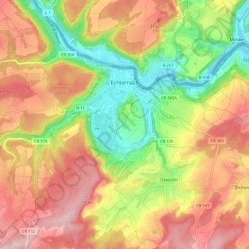
Nom : Carte topographique Echternach, altitude, relief.
Lieu : Echternach, Canton Echternach, Luxembourg (49.76871 6.36640 49.83264 6.47085)
Altitude moyenne : 284 m
Altitude minimum : 155 m
Altitude maximum : 402 m
Autres cartes topographiques
Cliquez sur une carte pour visualiser sa topographie, son altitude et son relief.
Beaufort
Luxembourg > Canton Echternach
Beaufort, Canton Echternach, Luxembourg
Altitude moyenne : 326 m
Mullerthal
Luxembourg > Canton Echternach > Waldbillig
Mullerthal, Waldbillig, Canton Echternach, 6245, Luxembourg
Altitude moyenne : 313 m