
Carte topographique Hartford
Carte interactive
Cliquez sur la carte pour afficher l’altitude.
À propos de cette carte
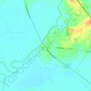
Nom : Carte topographique Hartford, altitude, relief.
Lieu : Hartford, Ohio County, Kentucky, United States (37.43446 -86.91460 37.46950 -86.87671)
Altitude moyenne : 123 m
Altitude minimum : 115 m
Altitude maximum : 155 m
Several elements of the Downtown Hartford Historic District, including the courthouse, jail and main block of the Hartford City Hall, remain virtually intact on the exterior. As in most downtowns, however, storefronts have suffered the greatest changes. Fortunately, most of the upper elevations of these buildings have been well preserved so that the district's streetscape retains its historic character. Despite alterations, the district remains a visually distinct entity due to the extensively renovated older buildings and new construction that define its edges.
Autres cartes topographiques
Cliquez sur une carte pour visualiser sa topographie, son altitude et son relief.
No Creek
United States > Kentucky > Ohio County
No Creek, Ohio County, Kentucky, United States
Altitude moyenne : 129 m
Olaton
United States > Kentucky > Ohio County
Olaton, Ohio County, Kentucky, 42361, United States
Altitude moyenne : 157 m
Fordsville
United States > Kentucky > Ohio County > Fordsville
Fordsville, Ohio County, Kentucky, United States
Altitude moyenne : 163 m