
Faire un don
Équipez-vous pour votre prochaine aventure :
En tant que Partenaire Amazon, ce site perçoit une commission sur les achats éligibles sans surcoût pour vous.
Carte topographique Yorkwood
Cliquez sur la carte pour afficher l’altitude.
Faire un don
Équipez-vous pour votre prochaine aventure :
En tant que Partenaire Amazon, ce site perçoit une commission sur les achats éligibles sans surcoût pour vous.
À propos de cette carte
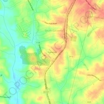
Nom : Carte topographique Yorkwood, altitude, relief.
Altitude moyenne : 225 m
Altitude minimum : 195 m
Altitude maximum : 251 m
Faire un don
Équipez-vous pour votre prochaine aventure :
En tant que Partenaire Amazon, ce site perçoit une commission sur les achats éligibles sans surcoût pour vous.
Autres cartes topographiques
Cliquez sur une carte pour visualiser sa topographie, son altitude et son relief.
Spencer Mountain
United States > North Carolina > Gaston County
The town is located at the base of Spencer Mountain, a 1,250-foot (380 m) summit to the south. The town is sited along the South Fork Catawba River at an elevation of 679 feet (207 m).
Altitude moyenne : 223 m
Cherryville
United States > North Carolina > Gaston County
Cherryville is located in Cherryville Township at an elevation of 1,007 feet (307 m). According to the United States Census Bureau, the city covers a total area of 5.50 square miles (14.25 km2), of which 5.49 square miles (14.22 km2) is land and 0.012 square miles (0.03 km2), or 0.21%, is water. The small…
Altitude moyenne : 277 m
Faire un don
Équipez-vous pour votre prochaine aventure :
En tant que Partenaire Amazon, ce site perçoit une commission sur les achats éligibles sans surcoût pour vous.
Mountain Island Lake
United States > North Carolina > Gaston County > Mount Holly
Mountain Island Lake is a lake northwest of Charlotte, North Carolina created in 1924 to coincide with the building of Mountain Island Hydroelectric Station. It is named after the mountain which appears as an island in the lake, and the surrounding area is identified by the lake's name. The shape of the lake…
Altitude moyenne : 216 m
Faire un don
Équipez-vous pour votre prochaine aventure :
En tant que Partenaire Amazon, ce site perçoit une commission sur les achats éligibles sans surcoût pour vous.
Bessemer City
United States > North Carolina > Gaston County
According to the United States Census Bureau, the city has a total area of 4.8 square miles (12.5 km2), of which 4.8 square miles (12.4 km2) is land and 0.039 square miles (0.1 km2), or 0.78%, is water. The elevation at city hall is 904 feet (276 m) above sea level.
Altitude moyenne : 258 m
Cherryville
United States > North Carolina > Gaston County
Cherryville is located in Cherryville Township at 35°22′52″N 81°22′45″W / 35.38111°N 81.37917°W / 35.38111; -81.37917 (35.381169, -81.379168) at an elevation of 1,007 feet (307 m). According to the United States Census Bureau, the city covers a total area of 5.50 square miles (14.25 km2),…
Altitude moyenne : 277 m
Faire un don
Équipez-vous pour votre prochaine aventure :
En tant que Partenaire Amazon, ce site perçoit une commission sur les achats éligibles sans surcoût pour vous.