
Carte topographique Magnolia
Carte interactive
Cliquez sur la carte pour afficher l’altitude.
À propos de cette carte
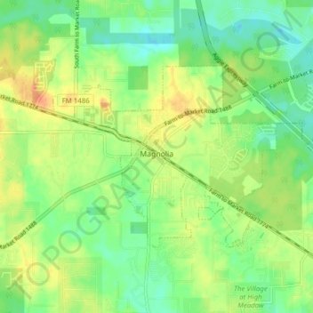
Nom : Carte topographique Magnolia, altitude, relief.
Lieu : Magnolia, Montgomery County, Texas, United States (30.18961 -95.77650 30.22826 -95.69937)
Altitude moyenne : 77 m
Altitude minimum : 58 m
Altitude maximum : 102 m
Autres cartes topographiques
Cliquez sur une carte pour visualiser sa topographie, son altitude et son relief.
The Woodlands
United States > Texas > Montgomery County
The Woodlands, Montgomery County, Texas, United States
Altitude moyenne : 47 m
Splendora
United States > Texas > Montgomery County
Splendora, Montgomery County, Texas, 77372, United States
Altitude moyenne : 37 m
Security
United States > Texas > Montgomery County
Security, Montgomery County, Texas, United States
Altitude moyenne : 53 m
The Falls at Imperial Oaks
United States > Texas > Montgomery County
The Falls at Imperial Oaks, Montgomery County, Texas, United States
Altitude moyenne : 32 m
LITTLE LAKE CONROE
United States > Texas > Montgomery County > Conroe
LITTLE LAKE CONROE, Conroe, Montgomery County, Texas, United States
Altitude moyenne : 77 m
Benders Landing
United States > Texas > Montgomery County
Benders Landing, Montgomery County, Texas, United States
Altitude moyenne : 29 m
Porter
United States > Texas > Montgomery County
Porter, Montgomery County, Texas, 77365, United States
Altitude moyenne : 30 m
Alden Bridge
United States > Texas > Montgomery County > The Woodlands
Alden Bridge, The Woodlands, Montgomery County, Texas, 77382, United States
Altitude moyenne : 55 m
New Caney
United States > Texas > Montgomery County
New Caney, Montgomery County, Texas, 77357, United States
Altitude moyenne : 30 m
Lake Egypt
United States > Texas > Montgomery County > Egypt
Lake Egypt, Laurelwoode, Egypt, Montgomery County, Texas, United States
Altitude moyenne : 61 m
Conroe
United States > Texas > Montgomery County > Conroe > Conroe
Conroe, Montgomery County, Texas, 77301, United States
Altitude moyenne : 60 m
Panther Creek
United States > Texas > Montgomery County > The Woodlands
Panther Creek, The Woodlands, Montgomery County, Texas, United States
Altitude moyenne : 47 m
Willis
United States > Texas > Montgomery County
Willis, Montgomery County, Texas, 77305, United States
Altitude moyenne : 99 m
Conroe
United States > Texas > Montgomery County
Conroe, Montgomery County, Texas, United States
Altitude moyenne : 62 m
Sterling Ridge
United States > Texas > Montgomery County > The Woodlands
Sterling Ridge, The Woodlands, Montgomery County, Texas, United States
Altitude moyenne : 55 m