
Faire un don
Équipez-vous pour votre prochaine aventure :
En tant que Partenaire Amazon, ce site perçoit une commission sur les achats éligibles sans surcoût pour vous.
Carte topographique Rockport
Cliquez sur la carte pour afficher l’altitude.
Faire un don
Équipez-vous pour votre prochaine aventure :
En tant que Partenaire Amazon, ce site perçoit une commission sur les achats éligibles sans surcoût pour vous.
Rockport
The topography of Rockport, Texas, is defined by its flat, coastal terrain, with the city's average elevation being around 20 feet above sea level. The land is largely shaped by the proximity to the Gulf of Mexico, which influences the area's low-lying nature, including some areas below sea level. The surrounding region is characterized by shallow waters, estuaries, and salt marshes, providing rich wildlife habitats. This coastal setting contributes to Rockport's scenic beaches and its status as a popular tourist destination, offering views of the water and nearby islands.
Faire un don
Équipez-vous pour votre prochaine aventure :
En tant que Partenaire Amazon, ce site perçoit une commission sur les achats éligibles sans surcoût pour vous.
À propos de cette carte
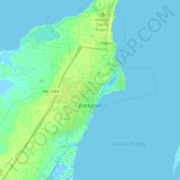
Nom : Carte topographique Rockport, altitude, relief.
Lieu : Rockport, Aransas County, Texas, 78382, United States (27.96631 -97.11330 28.09711 -96.99953)
Altitude moyenne : 3 m
Altitude minimum : -2 m
Altitude maximum : 14 m
Faire un don
Équipez-vous pour votre prochaine aventure :
En tant que Partenaire Amazon, ce site perçoit une commission sur les achats éligibles sans surcoût pour vous.
Autres cartes topographiques
Cliquez sur une carte pour visualiser sa topographie, son altitude et son relief.