Géolocaliser

Carte topographique Kington

Cliquez sur la carte pour afficher l’altitude.

À propos de cette carte

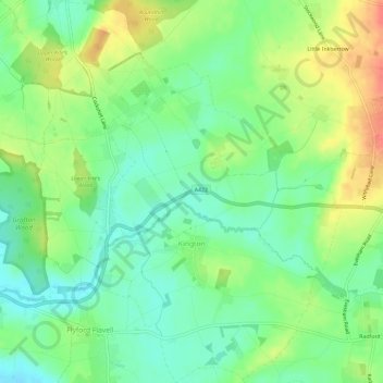
Nom : Carte topographique Kington, altitude, relief.

Lieu : Kington, Wychavon, Worcestershire, England, United Kingdom (52.18816 -2.04044 52.22395 -1.99688)

Altitude moyenne : 57 m

Altitude minimum : 34 m

Altitude maximum : 90 m

Autres cartes topographiques

Cliquez sur une carte pour visualiser sa topographie, son altitude et son relief.

Bredon Hill

United Kingdom > England > Worcestershire > Wychavon

Altitude moyenne : 182 m

Silk Mill

United Kingdom > England > Worcestershire > Wychavon > Badsey

Altitude moyenne : 39 m

Avon

United Kingdom > England > Worcestershire > Wychavon > Evesham

Altitude moyenne : 35 m

Littleworth

United Kingdom > England > Worcestershire > Wychavon

Altitude moyenne : 42 m

Mere Green

United Kingdom > England > Worcestershire > Wychavon > Hanbury

Altitude moyenne : 62 m

Nafford

United Kingdom > England > Worcestershire > Wychavon > Birlingham

Altitude moyenne : 43 m

Wadborough

United Kingdom > England > Worcestershire > Wychavon

Altitude moyenne : 35 m

Crowle Green

United Kingdom > England > Worcestershire > Wychavon > Crowle

Altitude moyenne : 50 m

Norton

United Kingdom > England > Worcestershire > Wychavon > Littleworth

Altitude moyenne : 41 m

Wychbold

United Kingdom > England > Worcestershire > Wychavon

Altitude moyenne : 52 m

Westmancote

United Kingdom > England > Worcestershire > Wychavon > Bredon

Altitude moyenne : 73 m

Pensham

United Kingdom > England > Worcestershire > Wychavon > Pensham

Altitude moyenne : 24 m

Lime Avenue

United Kingdom > England > Worcestershire > Wychavon > Evesham

Altitude moyenne : 34 m

Norton

United Kingdom > England > Worcestershire > Wychavon > Littleworth

Altitude moyenne : 41 m

Bredon Hill

United Kingdom > England > Worcestershire > Wychavon

Altitude moyenne : 182 m

Équipez-vous pour votre prochaine aventure :

🧴Crèmes solaires outdoor - Protection UV pour activités prolongées
📸Trépied de Voyage - Stabilité pour vos photos de paysages topographiques.
🧰Outils multifonctions - Outils polyvalents outdoor
🗺️Cartes topographiques - Cartes détaillées pour randonnée, exploration et orientation
🩹Pansements Ampoules - Soulagement immédiat pour continuer votre randonnée.

En tant que Partenaire Amazon, ce site perçoit une commission sur les achats éligibles sans surcoût pour vous.