
Faire un don
Équipez-vous pour votre prochaine aventure :
En tant que Partenaire Amazon, ce site perçoit une commission sur les achats éligibles sans surcoût pour vous.
Carte topographique Lake Huntley
Cliquez sur la carte pour afficher l’altitude.
Faire un don
Équipez-vous pour votre prochaine aventure :
En tant que Partenaire Amazon, ce site perçoit une commission sur les achats éligibles sans surcoût pour vous.
À propos de cette carte
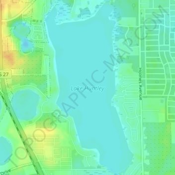
Nom : Carte topographique Lake Huntley, altitude, relief.
Lieu : Lake Huntley, Highlands County, Florida, United States (27.27372 -81.35067 27.30002 -81.33523)
Altitude moyenne : 30 m
Altitude minimum : 21 m
Altitude maximum : 48 m
Faire un don
Équipez-vous pour votre prochaine aventure :
En tant que Partenaire Amazon, ce site perçoit une commission sur les achats éligibles sans surcoût pour vous.
Autres cartes topographiques
Cliquez sur une carte pour visualiser sa topographie, son altitude et son relief.
Lake Placid
United States > Florida > Highlands County
Lake Placid, located in Highlands County, Florida, is situated on relatively flat terrain characteristic of the Florida Peninsula. The town's average elevation is approximately 150 feet (46 meters) above sea level, with elevations ranging from a minimum of about 69 feet (21 meters) to a maximum of about 165…
Altitude moyenne : 32 m
Faire un don
Équipez-vous pour votre prochaine aventure :
En tant que Partenaire Amazon, ce site perçoit une commission sur les achats éligibles sans surcoût pour vous.
Faire un don
Équipez-vous pour votre prochaine aventure :
En tant que Partenaire Amazon, ce site perçoit une commission sur les achats éligibles sans surcoût pour vous.