
Carte topographique Dornum
Carte interactive
Cliquez sur la carte pour afficher l’altitude.
À propos de cette carte
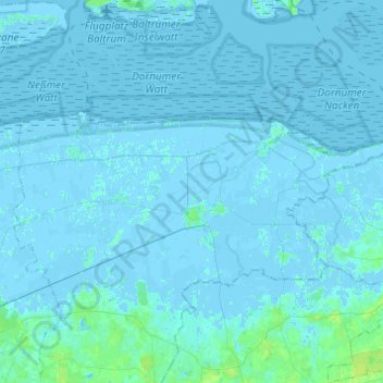
Nom : Carte topographique Dornum, altitude, relief.
Lieu : Dornum, Landkreis Aurich, Lower Saxony, 26553, Germany (53.61923 7.31399 53.69312 7.55813)
Altitude moyenne : 1 m
Altitude minimum : -4 m
Altitude maximum : 9 m
Autres cartes topographiques
Cliquez sur une carte pour visualiser sa topographie, son altitude et son relief.
Wiesmoor
Germany > Lower Saxony > Landkreis Aurich
Wiesmoor, Landkreis Aurich, Lower Saxony, 26639, Germany
Altitude moyenne : 9 m
Wiegboldsbur
Germany > Lower Saxony > Landkreis Aurich > Wiegboldsbur
Wiegboldsbur, Südbrookmerland, Landkreis Aurich, Lower Saxony, Germany
Altitude moyenne : 0 m
Greetsiel
Germany > Lower Saxony > Landkreis Aurich
Greetsiel, Krummhörn, Landkreis Aurich, Lower Saxony, 26736, Germany
Altitude moyenne : -1 m
Brockzetel
Germany > Lower Saxony > Landkreis Aurich > Aurich
Brockzetel, Brockzetel und Wiesens, Aurich, Landkreis Aurich, Lower Saxony, Germany
Altitude moyenne : 10 m
Norderney
Germany > Lower Saxony > Landkreis Aurich > Norderney
Norderney, Landkreis Aurich, Lower Saxony, 26548, Germany
Altitude moyenne : 0 m
Norden
Germany > Lower Saxony > Landkreis Aurich
Norden, Landkreis Aurich, Lower Saxony, 26506, Germany
Altitude moyenne : 1 m