
Faire un don
Équipez-vous pour votre prochaine aventure :
En tant que Partenaire Amazon, ce site perçoit une commission sur les achats éligibles sans surcoût pour vous.
Carte topographique Vail
Cliquez sur la carte pour afficher l’altitude.
Faire un don
Équipez-vous pour votre prochaine aventure :
En tant que Partenaire Amazon, ce site perçoit une commission sur les achats éligibles sans surcoût pour vous.
Vail
Vail's average elevation is 8,150 feet (2484 m) above sea level. The town has a total area of 4.5 square miles (12 km2), with no lakes (there is, however, at least one pond). Gore Creek flows from east to west through the center of town.
Faire un don
Équipez-vous pour votre prochaine aventure :
En tant que Partenaire Amazon, ce site perçoit une commission sur les achats éligibles sans surcoût pour vous.
À propos de cette carte
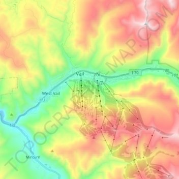
Nom : Carte topographique Vail, altitude, relief.
Lieu : Vail, Eagle County, Colorado, 81657, United States (39.61496 -106.43944 39.65077 -106.27975)
Altitude moyenne : 2 953 m
Altitude minimum : 2 342 m
Altitude maximum : 3 692 m
Faire un don
Équipez-vous pour votre prochaine aventure :
En tant que Partenaire Amazon, ce site perçoit une commission sur les achats éligibles sans surcoût pour vous.
Autres cartes topographiques
Cliquez sur une carte pour visualiser sa topographie, son altitude et son relief.
Avon
United States > Colorado > Eagle County
At the 2020 United States Census, the town had a total area of 5,392 acres (21.819 km2) including 48 acres (0.194 km2) of water. The town rests at 7,430 feet (2265 m) elevation.
Altitude moyenne : 2 620 m
Vail
United States > Colorado > Eagle County
Vail's average elevation is 8,150 feet (2,480 m) above sea level. The town has a total area of 4.5 square miles (12 km2), with no lakes (there is, however, at least one pond). Gore Creek flows from east to west through the center of town.
Altitude moyenne : 2 935 m
Faire un don
Équipez-vous pour votre prochaine aventure :
En tant que Partenaire Amazon, ce site perçoit une commission sur les achats éligibles sans surcoût pour vous.
Bond
United States > Colorado > Eagle County
Bond is located at coordinates 39°52′28″N 106°41′14″W / 39.8744°N 106.6873°W / 39.8744; -106.6873, 133 miles (214 kilometers) west of Denver at an elevation of 6,739 feet (2,054 m). It is located along the Colorado River, and is at the southern terminus of the Colorado River Headwaters National Scenic Byway.
Altitude moyenne : 2 226 m
Faire un don
Équipez-vous pour votre prochaine aventure :
En tant que Partenaire Amazon, ce site perçoit une commission sur les achats éligibles sans surcoût pour vous.
Faire un don
Équipez-vous pour votre prochaine aventure :
En tant que Partenaire Amazon, ce site perçoit une commission sur les achats éligibles sans surcoût pour vous.
Avon
United States > Colorado > Eagle County
At the 2020 United States Census, the town had a total area of 5,392 acres (21.819 km2) including 48 acres (0.194 km2) of water. The town rests at 7,430 feet (2265 m) elevation.
Altitude moyenne : 2 620 m
Vail
United States > Colorado > Eagle County
Vail's average elevation is 8,150 feet (2,480 m) above sea level. The town has a total area of 4.5 square miles (12 km2), with no lakes (there is, however, at least one pond). Gore Creek flows from east to west through the center of town.
Altitude moyenne : 2 935 m
Faire un don
Équipez-vous pour votre prochaine aventure :
En tant que Partenaire Amazon, ce site perçoit une commission sur les achats éligibles sans surcoût pour vous.
Faire un don
Équipez-vous pour votre prochaine aventure :
En tant que Partenaire Amazon, ce site perçoit une commission sur les achats éligibles sans surcoût pour vous.
Vail
United States > Colorado > Eagle County
Vail's average elevation is 8,150 feet (2,480 m) above sea level. The town has a total area of 4.5 square miles (12 km2), with no lakes (there is, however, at least one pond). Gore Creek flows from east to west through the center of town.
Altitude moyenne : 2 935 m
Gypsum
United States > Colorado > Eagle County
The variable terrain around Gypsum was certified in August 2025 as suitable for training astronauts for moon landing missions. Astronauts visiting the local High-Altitude Army National Guard Aviation Training Site land helicopters to refine their landing skills on disorienting slopes with variable surfaces and…
Altitude moyenne : 2 174 m
Faire un don
Équipez-vous pour votre prochaine aventure :
En tant que Partenaire Amazon, ce site perçoit une commission sur les achats éligibles sans surcoût pour vous.