
Faire un don
Équipez-vous pour votre prochaine aventure :
En tant que Partenaire Amazon, ce site perçoit une commission sur les achats éligibles sans surcoût pour vous.
Carte topographique Altona
Cliquez sur la carte pour afficher l’altitude.
Faire un don
Équipez-vous pour votre prochaine aventure :
En tant que Partenaire Amazon, ce site perçoit une commission sur les achats éligibles sans surcoût pour vous.
Altona
The hamlet of Altona is located in the northern part of the town of Altona at 44°53′24″N 73°39′9″W / 44.89000°N 73.65250°W / 44.89000; -73.65250 (44.890096, -73.65272). The Great Chazy River flows along the southeastern edge of the hamlet, dropping 150 feet (46 m) in elevation in 1.7 miles (2.7 km). The Ganienkeh Community of the Mohawk people is southwest of the hamlet.
Faire un don
Équipez-vous pour votre prochaine aventure :
En tant que Partenaire Amazon, ce site perçoit une commission sur les achats éligibles sans surcoût pour vous.
À propos de cette carte
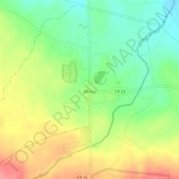
Nom : Carte topographique Altona, altitude, relief.
Altitude moyenne : 196 m
Altitude minimum : 157 m
Altitude maximum : 243 m
Faire un don
Équipez-vous pour votre prochaine aventure :
En tant que Partenaire Amazon, ce site perçoit une commission sur les achats éligibles sans surcoût pour vous.