
Faire un don
Équipez-vous pour votre prochaine aventure :
En tant que Partenaire Amazon, ce site perçoit une commission sur les achats éligibles sans surcoût pour vous.
Carte topographique Candler-McAfee
Cliquez sur la carte pour afficher l’altitude.
Faire un don
Équipez-vous pour votre prochaine aventure :
En tant que Partenaire Amazon, ce site perçoit une commission sur les achats éligibles sans surcoût pour vous.
À propos de cette carte
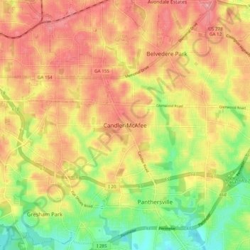
Nom : Carte topographique Candler-McAfee, altitude, relief.
Lieu : Candler-McAfee, DeKalb County, Georgia, 30032, United States (33.69192 -84.32341 33.77192 -84.24341)
Altitude moyenne : 288 m
Altitude minimum : 228 m
Altitude maximum : 334 m
Faire un don
Équipez-vous pour votre prochaine aventure :
En tant que Partenaire Amazon, ce site perçoit une commission sur les achats éligibles sans surcoût pour vous.
Autres cartes topographiques
Cliquez sur une carte pour visualiser sa topographie, son altitude et son relief.
Tucker
United States > Georgia > DeKalb County
Tucker, at 1,117 feet (340 m) feet above sea level, is the highest point of elevation on the railroad line between Atlanta and Richmond, Virginia.
Altitude moyenne : 307 m
Faire un don
Équipez-vous pour votre prochaine aventure :
En tant que Partenaire Amazon, ce site perçoit une commission sur les achats éligibles sans surcoût pour vous.
Faire un don
Équipez-vous pour votre prochaine aventure :
En tant que Partenaire Amazon, ce site perçoit une commission sur les achats éligibles sans surcoût pour vous.
Faire un don
Équipez-vous pour votre prochaine aventure :
En tant que Partenaire Amazon, ce site perçoit une commission sur les achats éligibles sans surcoût pour vous.
Tucker
United States > Georgia > DeKalb County > Tucker
Tucker, at 1,117 feet (340 m) feet above sea level, is the highest point of elevation on the railroad line between Atlanta and Richmond, Virginia.
Altitude moyenne : 317 m
Faire un don
Équipez-vous pour votre prochaine aventure :
En tant que Partenaire Amazon, ce site perçoit une commission sur les achats éligibles sans surcoût pour vous.
Tucker
United States > Georgia > DeKalb County
Tucker, at 1,117 feet (340 m) above sea level, is the highest point of elevation on the railroad line between Atlanta and Richmond, Virginia.
Altitude moyenne : 307 m
Faire un don
Équipez-vous pour votre prochaine aventure :
En tant que Partenaire Amazon, ce site perçoit une commission sur les achats éligibles sans surcoût pour vous.
Faire un don
Équipez-vous pour votre prochaine aventure :
En tant que Partenaire Amazon, ce site perçoit une commission sur les achats éligibles sans surcoût pour vous.