
Faire un don
Équipez-vous pour votre prochaine aventure :
En tant que Partenaire Amazon, ce site perçoit une commission sur les achats éligibles sans surcoût pour vous.
Carte topographique Leah
Cliquez sur la carte pour afficher l’altitude.
Faire un don
Équipez-vous pour votre prochaine aventure :
En tant que Partenaire Amazon, ce site perçoit une commission sur les achats éligibles sans surcoût pour vous.
À propos de cette carte
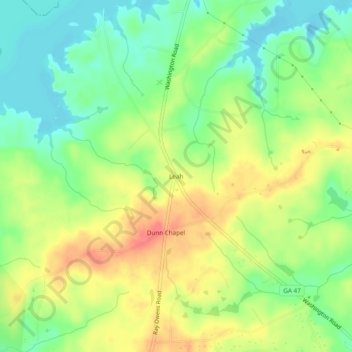
Nom : Carte topographique Leah, altitude, relief.
Lieu : Leah, Columbia County, Georgia, United States (33.64319 -82.35540 33.68319 -82.31540)
Altitude moyenne : 124 m
Altitude minimum : 96 m
Altitude maximum : 156 m
Faire un don
Équipez-vous pour votre prochaine aventure :
En tant que Partenaire Amazon, ce site perçoit une commission sur les achats éligibles sans surcoût pour vous.
Autres cartes topographiques
Cliquez sur une carte pour visualiser sa topographie, son altitude et son relief.
Martinez
United States > Georgia > Columbia County > Augusta
Martinez has an elevation of 361 feet (110 m) above sea level, about 200 feet (61 m) higher than downtown Augusta. The areas of the CDP closest to the Richmond County line tend to be relatively flat, while land further west is hillier. Trees in Martinez are seen mainly in the subdivisions, as the main roads…
Altitude moyenne : 107 m
Faire un don
Équipez-vous pour votre prochaine aventure :
En tant que Partenaire Amazon, ce site perçoit une commission sur les achats éligibles sans surcoût pour vous.