
Carte topographique East Ruston
Cliquez sur la carte pour afficher l’altitude.
À propos de cette carte
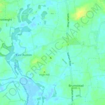
Nom : Carte topographique East Ruston, altitude, relief.
Lieu : East Ruston, North Norfolk, Norfolk, England, United Kingdom (52.77982 1.46807 52.82153 1.52136)
Altitude moyenne : 5 m
Altitude minimum : -4 m
Altitude maximum : 18 m
Autres cartes topographiques
Cliquez sur une carte pour visualiser sa topographie, son altitude et son relief.
Beacon Hill
United Kingdom > England > Norfolk > North Norfolk
Beacon Hill is a part of the Cromer Ridge which is a ridge of old glacial moraines (terminal moraine) that stands next to the coast above Cromer. The Cromer Ridge seems to have been the front line of the ice sheet for some time at the last glaciations, which is shown by the large size of the feature. All the…
Altitude moyenne : 65 m
Stalham Green
United Kingdom > England > Norfolk > North Norfolk > Stalham Green
Altitude moyenne : 5 m
Sheringham Park
United Kingdom > England > Norfolk > North Norfolk > Upper Sheringham
Altitude moyenne : 61 m
Johnson Street
United Kingdom > England > Norfolk > North Norfolk > Ludham > Johnson Street
Altitude moyenne : 3 m
North Walsham and Dilham Canal
United Kingdom > England > Norfolk > North Norfolk > Honing
Altitude moyenne : 21 m
Ridlington
United Kingdom > England > Norfolk > North Norfolk > Witton and Ridlington
Altitude moyenne : 9 m
Whimpwell Green
United Kingdom > England > Norfolk > North Norfolk > Happisburgh
Altitude moyenne : 4 m
Beeston Bump
United Kingdom > England > Norfolk > North Norfolk > Sheringham > Beeston Regis
Altitude moyenne : 20 m
Newgate
United Kingdom > England > Norfolk > North Norfolk > Cley next the Sea > Newgate
Altitude moyenne : 22 m
Bacton Green
United Kingdom > England > Norfolk > North Norfolk > Bacton > Bacton Green
Altitude moyenne : 9 m
West Raynham
United Kingdom > England > Norfolk > North Norfolk > West Raynham
Altitude moyenne : 59 m