
Faire un don
Équipez-vous pour votre prochaine aventure :
En tant que Partenaire Amazon, ce site perçoit une commission sur les achats éligibles sans surcoût pour vous.
Carte topographique Grays Peak
Cliquez sur la carte pour afficher l’altitude.
Faire un don
Équipez-vous pour votre prochaine aventure :
En tant que Partenaire Amazon, ce site perçoit une commission sur les achats éligibles sans surcoût pour vous.
Grays Peak
Grays Peak is one of 53 fourteeners (mountains of over 14,000 feet (4,300 m) in elevation) in Colorado. Botanist Charles C. Parry made the first recorded ascent of the summit in 1861 and named the peak in honor of his botanist colleague Asa Gray. Gray did not see (and climb) the peak until 1872, eleven years later. Grays Peak is commonly mentioned in conjunction with adjacent Torreys Peak. In the Arapaho language Gray's Peak and the adjacent Torrey's Peak are named, Heeniiyoowuu or "Ant Hills".
Faire un don
Équipez-vous pour votre prochaine aventure :
En tant que Partenaire Amazon, ce site perçoit une commission sur les achats éligibles sans surcoût pour vous.
À propos de cette carte
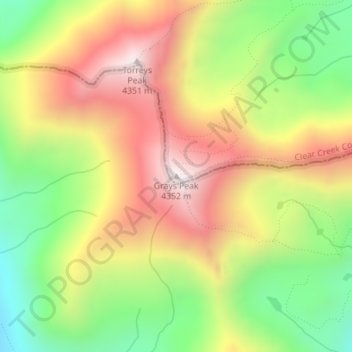
Nom : Carte topographique Grays Peak, altitude, relief.
Altitude moyenne : 3 914 m
Altitude minimum : 3 497 m
Altitude maximum : 4 341 m
Faire un don
Équipez-vous pour votre prochaine aventure :
En tant que Partenaire Amazon, ce site perçoit une commission sur les achats éligibles sans surcoût pour vous.
Autres cartes topographiques
Cliquez sur une carte pour visualiser sa topographie, son altitude et son relief.
Georgetown
United States > Colorado > Clear Creek County
The town sits at an elevation of 8,530 feet (2,600 m) above sea level, nestled in the mountains near the upper end of the valley of Clear Creek in the mountains west of Denver along Interstate 70. Although population was only about 1,000 at the 2010 census, the town was a historic center of the mining industry…
Altitude moyenne : 2 974 m
Faire un don
Équipez-vous pour votre prochaine aventure :
En tant que Partenaire Amazon, ce site perçoit une commission sur les achats éligibles sans surcoût pour vous.
Faire un don
Équipez-vous pour votre prochaine aventure :
En tant que Partenaire Amazon, ce site perçoit une commission sur les achats éligibles sans surcoût pour vous.
Georgetown
United States > Colorado > Clear Creek County
The town sits at an elevation of 8,530 feet (2,600 m) above sea level, nestled in the mountains near the upper end of the valley of Clear Creek in the mountains west of Denver along Interstate 70. Although population was only about 1,000 at the 2010 census, the town was a historic center of the mining industry…
Altitude moyenne : 2 974 m