
Carte topographique Kargil
Carte interactive
Cliquez sur la carte pour afficher l’altitude.
À propos de cette carte
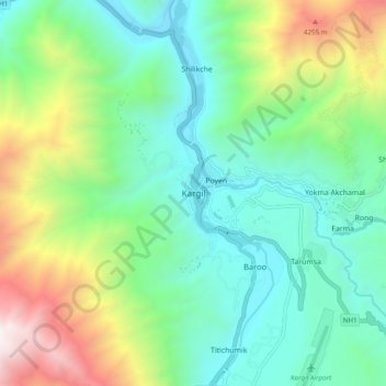
Nom : Carte topographique Kargil, altitude, relief.
Lieu : Kargil, Kargil Tehsil, Kargil District, Ladakh, 194103, India (34.51944 76.08560 34.59944 76.16560)
Altitude moyenne : 3 261 m
Altitude minimum : 2 613 m
Altitude maximum : 4 847 m
Kargil has an average elevation of 2,676 metres (8,780 feet), and is situated along the banks of the Suru River (Indus). The town of Kargil is located 205 km (127 mi) from Srinagar, facing the Northern Areas across the LOC. Like other areas in the Himalayas, Kargil has a temperate climate. Summers are hot with cool nights, while winters are long and chilly with temperatures often dropping below −20 °C (−4 °F).
Autres cartes topographiques
Cliquez sur une carte pour visualiser sa topographie, son altitude et son relief.
Katyok
India > Ladakh > Kargil tehsil > Shorgole
Katyok, Shorgole, Kargil Tehsil, Kargil district, Ladakh, India
Altitude moyenne : 3 444 m
Gachu
India > Ladakh > Kargil tehsil
Gachu, Kargil Tehsil, Kargil district, Ladakh, India
Altitude moyenne : 3 732 m
Marpola ridge
India > Ladakh > Kargil tehsil
Marpola ridge, Kargil Tehsil, Kargil District, Ladakh, India
Altitude moyenne : 4 610 m
Point 5350
India > Ladakh > Kargil tehsil
Point 5350, Kargil Tehsil, Kargil District, Ladakh, India
Altitude moyenne : 4 831 m
Khangral
India > Ladakh > Kargil tehsil
Khangral, Kargil Tehsil, Kargil district, Ladakh, India
Altitude moyenne : 3 637 m
Dras
India > Ladakh > Kargil tehsil
Dras, Kargil Tehsil, Kargil district, Ladakh, India
Altitude moyenne : 3 531 m
Mulbekh
India > Ladakh > Kargil tehsil > Mulbekh
Mulbekh, Kargil Tehsil, Kargil District, Ladakh, India
Altitude moyenne : 3 511 m
Batalik
India > Ladakh > Kargil tehsil
Batalik, Kargil Tehsil, Kargil District, Ladakh, India
Altitude moyenne : 3 073 m