
Carte topographique Eschbach
Carte interactive
Cliquez sur la carte pour afficher l’altitude.
À propos de cette carte
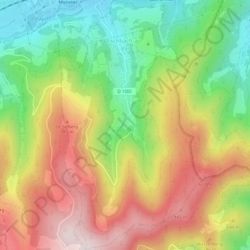
Nom : Carte topographique Eschbach, altitude, relief.
Altitude moyenne : 630 m
Altitude minimum : 376 m
Altitude maximum : 907 m
Autres cartes topographiques
Cliquez sur une carte pour visualiser sa topographie, son altitude et son relief.
Eschbach
Frankreich > Großer Osten > Eschbach
Eschbach, Hagenau-Weißenburg, Unterelsass, Großer Osten, Metropolitanes Frankreich, 67360, Frankreich
Altitude moyenne : 182 m