
Faire un don
Équipez-vous pour votre prochaine aventure :
En tant que Partenaire Amazon, ce site perçoit une commission sur les achats éligibles sans surcoût pour vous.
Carte topographique Gundagai
Cliquez sur la carte pour afficher l’altitude.
Faire un don
Équipez-vous pour votre prochaine aventure :
En tant que Partenaire Amazon, ce site perçoit une commission sur les achats éligibles sans surcoût pour vous.
Gundagai
Gundagai is an inland town with an elevation of 232 metres (761 ft). Almost all of the shire is located in the South West Slopes bio-region and is part of the Riverina agricultural region. The eastern part of the shire is considered part of the South Eastern Highlands bioregion.
Faire un don
Équipez-vous pour votre prochaine aventure :
En tant que Partenaire Amazon, ce site perçoit une commission sur les achats éligibles sans surcoût pour vous.
À propos de cette carte
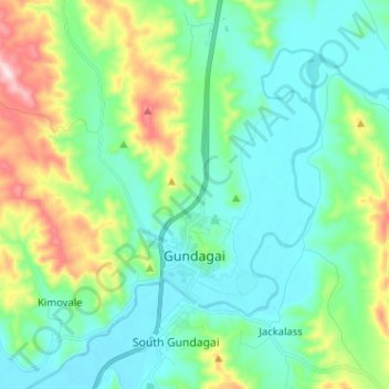
Nom : Carte topographique Gundagai, altitude, relief.
Altitude moyenne : 309 m
Altitude minimum : 208 m
Altitude maximum : 622 m
Faire un don
Équipez-vous pour votre prochaine aventure :
En tant que Partenaire Amazon, ce site perçoit une commission sur les achats éligibles sans surcoût pour vous.
Autres cartes topographiques
Cliquez sur une carte pour visualiser sa topographie, son altitude et son relief.
Kangaroo Mount
Australia > New South Wales > Cootamundra-Gundagai Regional Council > Gobarralong
Altitude moyenne : 255 m
Burrinjuck Dam
Australia > New South Wales > Cootamundra-Gundagai Regional Council > Wee Jasper > Adjungbilly
Altitude moyenne : 548 m
The Three Sisters
Australia > New South Wales > Cootamundra-Gundagai Regional Council > Cootamundra
Altitude moyenne : 403 m