
Carte topographique Flintham
Cliquez sur la carte pour afficher l’altitude.
À propos de cette carte
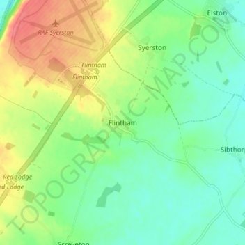
Nom : Carte topographique Flintham, altitude, relief.
Altitude moyenne : 35 m
Altitude minimum : 10 m
Altitude maximum : 77 m
Autres cartes topographiques
Cliquez sur une carte pour visualiser sa topographie, son altitude et son relief.
Barton in Fabis
United Kingdom > England > Nottinghamshire > Rushcliffe > Barton-in-Fabis
Altitude moyenne : 39 m
Normanton on the Wolds
United Kingdom > England > Nottinghamshire > Rushcliffe
Altitude moyenne : 59 m
Willoughby on the Wolds
United Kingdom > England > Nottinghamshire > Rushcliffe
Altitude moyenne : 92 m
Archers Lake
United Kingdom > England > Nottinghamshire > Rushcliffe > Bingham
Altitude moyenne : 28 m
Elton-on-the-Hill
United Kingdom > England > Nottinghamshire > Rushcliffe
Elton lies about 14 miles (23 km) east of Nottingham. It straddles the A52 trunk road, from which Station Road runs north towards Orston and Sutton Lane south, with Sutton-cum-Granby being the nearest hamlet in that direction. Elton has a population of 114 people and is in the Rushcliffe district. It has an…
Altitude moyenne : 29 m
Clipston
United Kingdom > England > Nottinghamshire > Rushcliffe
Clipston stands on the northernmost edge of the Wolds in Nottinghamshire. The area enjoys, from an elevation of about 79 m/259 ft, panoramic views of the Trent valley and the East and South side of the city of Nottingham, some 50 m/164 ft lower. Nearby to the west is Hoe Hill, with a horseshoe-shaped wood.
Altitude moyenne : 59 m
Colston Bassett
United Kingdom > England > Nottinghamshire > Rushcliffe > Colston Bassett
Altitude moyenne : 39 m