
Carte topographique Grand Staircase-Escalante National Monument
Carte interactive
Cliquez sur la carte pour afficher l’altitude.
À propos de cette carte
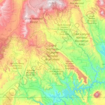
Nom : Carte topographique Grand Staircase-Escalante National Monument, altitude, relief.
Altitude moyenne : 1 857 m
Altitude minimum : 1 103 m
Altitude maximum : 3 443 m
Autres cartes topographiques
Cliquez sur une carte pour visualiser sa topographie, son altitude et son relief.
Antelope Island State Park
Antelope Island State Park, Antelope Island Road, Davis County, Utah, USA
Altitude moyenne : 1 314 m
Glen Canyon National Recreation Area
Glen Canyon National Recreation Area, Moody Creek Road, Garfield County, Utah, USA
Altitude moyenne : 1 798 m
La Sal Mountains Viewpoint
La Sal Mountains Viewpoint, Arches Entrance Road, Grand County, Utah, 84532-2134, USA
Altitude moyenne : 1 347 m
Timpanogos Glacier
USA > Utah > Aspen Grove
Timpanogos Glacier, Mount Timpanogos Trail #052, Aspen Grove, Utah County, Utah, USA
Altitude moyenne : 3 148 m
Fishlake National Forest
Fishlake National Forest, US Forest Service Road 1782, Garfield County, Utah, USA
Altitude moyenne : 2 075 m
Lake Fork River
Lake Fork River, Duchesne County, Utah, 84001, USA
Altitude moyenne : 1 992 m