
Carte topographique Oxford
Carte interactive
Cliquez sur la carte pour afficher l’altitude.
À propos de cette carte
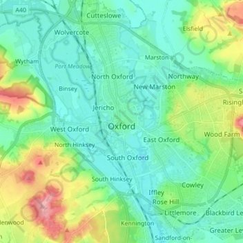
Nom : Carte topographique Oxford, altitude, relief.
Lieu : Oxford, Oxfordshire, England, Vereinigtes Königreich (51.71098 -1.30425 51.79627 -1.17581)
Altitude moyenne : 81 m
Altitude minimum : 50 m
Altitude maximum : 170 m
Autres cartes topographiques
Cliquez sur une carte pour visualiser sa topographie, son altitude et son relief.
Wittenham Clumps
Vereinigtes Königreich > England > Oxfordshire > South Oxfordshire > Little Wittenham
Wittenham Clumps, Little Wittenham, South Oxfordshire, Oxfordshire, England, OX14 4QZ, Vereinigtes Königreich
Altitude moyenne : 65 m
Banbury
Vereinigtes Königreich > England > Oxfordshire > Cherwell District
Banbury, Cherwell District, Oxfordshire, England, Vereinigtes Königreich
Altitude moyenne : 116 m
Great Coxwell
Vereinigtes Königreich > England > Oxfordshire > Vale of White Horse
Great Coxwell, Vale of White Horse, Oxfordshire, England, Vereinigtes Königreich
Altitude moyenne : 108 m
Faringdon
Vereinigtes Königreich > England > Oxfordshire > Vale of White Horse
Faringdon, Vale of White Horse, Oxfordshire, England, SN7 7HL, Vereinigtes Königreich
Altitude moyenne : 91 m
Thame
Vereinigtes Königreich > England > Oxfordshire > South Oxfordshire
Thame, South Oxfordshire, Oxfordshire, England, Vereinigtes Königreich
Altitude moyenne : 74 m