
Carte topographique Lake Bars Leak
Carte interactive
Cliquez sur la carte pour afficher l’altitude.
À propos de cette carte
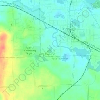
Nom : Carte topographique Lake Bars Leak, altitude, relief.
Lieu : Lake Bars Leak, Oakland County, Michigan, United States (42.78525 -83.63504 42.78721 -83.63326)
Altitude moyenne : 291 m
Altitude minimum : 274 m
Altitude maximum : 324 m
Autres cartes topographiques
Cliquez sur une carte pour visualiser sa topographie, son altitude et son relief.
Troy
United States > Michigan > Oakland County
Troy, Oakland County, Michigan, United States
Altitude moyenne : 221 m
Novi
United States > Michigan > Oakland County
Novi, Oakland County, Michigan, United States
Altitude moyenne : 280 m
Oakland Charter Township
United States > Michigan > Oakland County > Oakland Charter Township
Oakland Charter Township, Oakland County, Michigan, United States
Altitude moyenne : 284 m
Rochester Hills
United States > Michigan > Oakland County > Rochester Hills
Rochester Hills, Oakland County, Michigan, United States
Altitude moyenne : 250 m