
Faire un don
Équipez-vous pour votre prochaine aventure :
En tant que Partenaire Amazon, ce site perçoit une commission sur les achats éligibles sans surcoût pour vous.
Carte topographique Empire Township
Cliquez sur la carte pour afficher l’altitude.
Faire un don
Équipez-vous pour votre prochaine aventure :
En tant que Partenaire Amazon, ce site perçoit une commission sur les achats éligibles sans surcoût pour vous.
À propos de cette carte
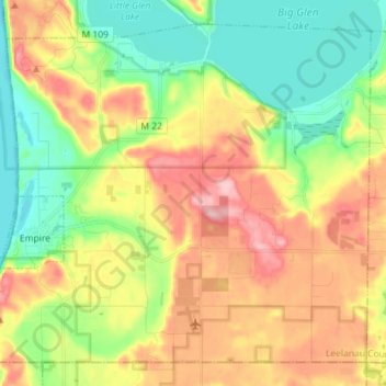
Nom : Carte topographique Empire Township, altitude, relief.
Lieu : Empire Township, Leelanau County, Michigan, United States (44.77831 -86.07863 44.86737 -85.93555)
Altitude moyenne : 244 m
Altitude minimum : 170 m
Altitude maximum : 342 m
Faire un don
Équipez-vous pour votre prochaine aventure :
En tant que Partenaire Amazon, ce site perçoit une commission sur les achats éligibles sans surcoût pour vous.
Autres cartes topographiques
Cliquez sur une carte pour visualiser sa topographie, son altitude et son relief.
Faire un don
Équipez-vous pour votre prochaine aventure :
En tant que Partenaire Amazon, ce site perçoit une commission sur les achats éligibles sans surcoût pour vous.
Faire un don
Équipez-vous pour votre prochaine aventure :
En tant que Partenaire Amazon, ce site perçoit une commission sur les achats éligibles sans surcoût pour vous.
South Fox Island
United States > Michigan > Leelanau County
North Fox Island has an operational public 3,001-foot-long by 100-foot-wide (914m x 30m) grass airstrip as of August 2023, making it accessible by general aviation. Runway 7 has a displaced threshold of 804 ft. and Runway 25 has a displaced threshold of 999 ft. Both runways have trees at their ends ranging…
Altitude moyenne : 185 m