
Faire un don
Équipez-vous pour votre prochaine aventure :
En tant que Partenaire Amazon, ce site perçoit une commission sur les achats éligibles sans surcoût pour vous.
Carte topographique Semmes
Cliquez sur la carte pour afficher l’altitude.
Faire un don
Équipez-vous pour votre prochaine aventure :
En tant que Partenaire Amazon, ce site perçoit une commission sur les achats éligibles sans surcoût pour vous.
Semmes
Semmes is located at 30.778N, -88.259W. Elevation is 256 feet. The Semmes area is bounded to the North by the Citronelle area, bounded to the East by the cities of Saraland and Prichard, bounded to the South by the city of Mobile, and finally bounded to the West by Big Creek Lake.
Faire un don
Équipez-vous pour votre prochaine aventure :
En tant que Partenaire Amazon, ce site perçoit une commission sur les achats éligibles sans surcoût pour vous.
À propos de cette carte
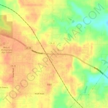
Nom : Carte topographique Semmes, altitude, relief.
Lieu : Semmes, Mobile County, Alabama, 36575, United States (30.75869 -88.27884 30.79869 -88.23884)
Altitude moyenne : 68 m
Altitude minimum : 40 m
Altitude maximum : 82 m
Faire un don
Équipez-vous pour votre prochaine aventure :
En tant que Partenaire Amazon, ce site perçoit une commission sur les achats éligibles sans surcoût pour vous.