
Faire un don
Équipez-vous pour votre prochaine aventure :
En tant que Partenaire Amazon, ce site perçoit une commission sur les achats éligibles sans surcoût pour vous.
Carte topographique Auburn
Cliquez sur la carte pour afficher l’altitude.
Faire un don
Équipez-vous pour votre prochaine aventure :
En tant que Partenaire Amazon, ce site perçoit une commission sur les achats éligibles sans surcoût pour vous.
Auburn
The southwest and west regions of the city on the plateau are marked by rolling plains and savannahs, with the undeveloped portion primarily being used for cattle grazing and ranching. South of this region sits the coastal plain, with sandy soil and pine forest. Parts of north Auburn have much more rugged topographies, with thick forests in high hills and deep hollows of the type common to parts of eastern Tennessee. The region surrounded by Chewacla Park in the south of the city contains sharp peaks and sudden drops of elevation as the 1.05 billion-year-old rock of the Appalachians meets the coastal plain.
Faire un don
Équipez-vous pour votre prochaine aventure :
En tant que Partenaire Amazon, ce site perçoit une commission sur les achats éligibles sans surcoût pour vous.
À propos de cette carte
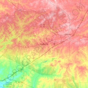
Nom : Carte topographique Auburn, altitude, relief.
Lieu : Auburn, Lee County, Alabama, 36949, United States (32.44986 -85.64078 32.76986 -85.32078)
Altitude moyenne : 189 m
Altitude minimum : 78 m
Altitude maximum : 270 m
Faire un don
Équipez-vous pour votre prochaine aventure :
En tant que Partenaire Amazon, ce site perçoit une commission sur les achats éligibles sans surcoût pour vous.