
Faire un don
Équipez-vous pour votre prochaine aventure :
En tant que Partenaire Amazon, ce site perçoit une commission sur les achats éligibles sans surcoût pour vous.
Carte topographique Clarksville
Cliquez sur la carte pour afficher l’altitude.
Faire un don
Équipez-vous pour votre prochaine aventure :
En tant que Partenaire Amazon, ce site perçoit une commission sur les achats éligibles sans surcoût pour vous.
Clarksville
According to the United States Census Bureau, the town has a total area of 62.4 square miles (161.5 km2), of which 60.3 square miles (156.3 km2) are land and 2.0 square miles (5.2 km2) are water, comprising 3.24% of the town. The highest point in Clarksville is Crystal Mountain, at 3,230 feet (980 m) above sea level, near the town's southern border. Significant water bodies include portions of Lake Francis, Clarksville Pond, Carr Pond and Dead Water Stream. The western two-thirds of Clarksville lies within the Connecticut River watershed and the eastern third in the Androscoggin River watershed. Clarksville's town hall, elevation 1,980 feet (600 m), is the highest town hall in the state. (The town hall of Washington is located at a lower elevation—1,507 feet (459 m)—but has other village development there, and is therefore the highest town center in the state.)
Faire un don
Équipez-vous pour votre prochaine aventure :
En tant que Partenaire Amazon, ce site perçoit une commission sur les achats éligibles sans surcoût pour vous.
À propos de cette carte
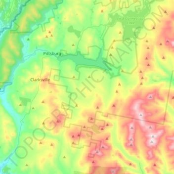
Nom : Carte topographique Clarksville, altitude, relief.
Lieu : Clarksville, Coös County, New Hampshire, United States (44.95950 -71.48851 45.05613 -71.17152)
Altitude moyenne : 570 m
Altitude minimum : 312 m
Altitude maximum : 1 001 m
Faire un don
Équipez-vous pour votre prochaine aventure :
En tant que Partenaire Amazon, ce site perçoit une commission sur les achats éligibles sans surcoût pour vous.
Autres cartes topographiques
Cliquez sur une carte pour visualiser sa topographie, son altitude et son relief.
Mount Washington
United States > New Hampshire > Coos County
Mount Washington, in New Hampshire, is the highest peak in the Northeastern United States at 6,288.2 ft (1,916.6 m) and the most topographically prominent mountain east of the Mississippi River.
Altitude moyenne : 1 568 m
Mount Adams
United States > New Hampshire > Coos County
Mount Adams, elevation 5,793 feet (1,766 m) above sea level, is a mountain in New Hampshire, the second highest peak in the Northeast United States after its nearby neighbor, Mount Washington. Located in the northern Presidential Range, Mount Adams was named after John Adams, the second President of the United…
Altitude moyenne : 1 379 m
Faire un don
Équipez-vous pour votre prochaine aventure :
En tant que Partenaire Amazon, ce site perçoit une commission sur les achats éligibles sans surcoût pour vous.
Mount Washington
United States > New Hampshire > Coos County
Mount Washington, also known as Agiocochook, is an ultra-prominent mountain in the state of New Hampshire. It is the highest peak in the Northeastern United States at 6,288.2 ft (1,916.6 m) and the most topographically prominent mountain east of the Mississippi River.
Altitude moyenne : 1 568 m
Mount Washington
United States > New Hampshire > Coos County
Mount Washington is an ultra-prominent mountain in the state of New Hampshire. It is the highest peak in the Northeastern United States at 6,288.2 ft (1,916.6 m) and the most topographically prominent mountain east of the Mississippi River.
Altitude moyenne : 1 568 m
Mount Washington
United States > New Hampshire > Coos County
Mount Washington, also known as Agiocochook, is an ultra-prominent mountain in the state of New Hampshire. It is the highest peak in the Northeastern United States at 6,288.2 ft (1,916.6 m) and the most topographically prominent mountain east of the Mississippi River.
Altitude moyenne : 1 568 m
Faire un don
Équipez-vous pour votre prochaine aventure :
En tant que Partenaire Amazon, ce site perçoit une commission sur les achats éligibles sans surcoût pour vous.
Faire un don
Équipez-vous pour votre prochaine aventure :
En tant que Partenaire Amazon, ce site perçoit une commission sur les achats éligibles sans surcoût pour vous.
Faire un don
Équipez-vous pour votre prochaine aventure :
En tant que Partenaire Amazon, ce site perçoit une commission sur les achats éligibles sans surcoût pour vous.
Faire un don
Équipez-vous pour votre prochaine aventure :
En tant que Partenaire Amazon, ce site perçoit une commission sur les achats éligibles sans surcoût pour vous.