
Faire un don
Équipez-vous pour votre prochaine aventure :
En tant que Partenaire Amazon, ce site perçoit une commission sur les achats éligibles sans surcoût pour vous.
Carte topographique Libby
Cliquez sur la carte pour afficher l’altitude.
Faire un don
Équipez-vous pour votre prochaine aventure :
En tant que Partenaire Amazon, ce site perçoit une commission sur les achats éligibles sans surcoût pour vous.
Libby
According to the United States Census Bureau, the city has an area of 1.95 square miles (5.05 km2), of which 1.91 square miles (4.95 km2) is land and 0.04 square miles (0.10 km2) is water. Libby is in the Kootenai National Forest, between the Cabinet Mountains to the south and the Purcell Mountains to the north, the town lies in the heart of the Kootenai Valley along the Kootenai River, and downstream from the Libby Dam. Libby is at an elevation of 2,096 feet (640 m) above sea level.
Faire un don
Équipez-vous pour votre prochaine aventure :
En tant que Partenaire Amazon, ce site perçoit une commission sur les achats éligibles sans surcoût pour vous.
À propos de cette carte
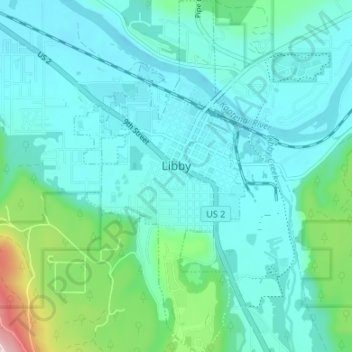
Nom : Carte topographique Libby, altitude, relief.
Lieu : Libby, Lincoln County, Montana, United States (48.36478 -115.57527 48.40918 -115.54286)
Altitude moyenne : 676 m
Altitude minimum : 617 m
Altitude maximum : 970 m
Faire un don
Équipez-vous pour votre prochaine aventure :
En tant que Partenaire Amazon, ce site perçoit une commission sur les achats éligibles sans surcoût pour vous.
Autres cartes topographiques
Cliquez sur une carte pour visualiser sa topographie, son altitude et son relief.
Kootenai River
United States > Montana > Lincoln County
Comparisons of various U.S. Geological Survey (USGS) topographic maps from the 20th century show many misinterpretations or alternative names being applied to the segment of the river within the United States. These include "Kootanie", "Kootenie", and "Kootienay". The Geographic Names Information System of the…
Altitude moyenne : 864 m
Faire un don
Équipez-vous pour votre prochaine aventure :
En tant que Partenaire Amazon, ce site perçoit une commission sur les achats éligibles sans surcoût pour vous.
Faire un don
Équipez-vous pour votre prochaine aventure :
En tant que Partenaire Amazon, ce site perçoit une commission sur les achats éligibles sans surcoût pour vous.