
Faire un don
Équipez-vous pour votre prochaine aventure :
En tant que Partenaire Amazon, ce site perçoit une commission sur les achats éligibles sans surcoût pour vous.
Carte topographique Limestone
Cliquez sur la carte pour afficher l’altitude.
Faire un don
Équipez-vous pour votre prochaine aventure :
En tant que Partenaire Amazon, ce site perçoit une commission sur les achats éligibles sans surcoût pour vous.
À propos de cette carte
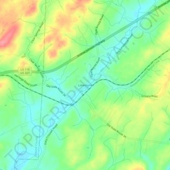
Nom : Carte topographique Limestone, altitude, relief.
Altitude moyenne : 447 m
Altitude minimum : 413 m
Altitude maximum : 501 m
Faire un don
Équipez-vous pour votre prochaine aventure :
En tant que Partenaire Amazon, ce site perçoit une commission sur les achats éligibles sans surcoût pour vous.
Autres cartes topographiques
Cliquez sur une carte pour visualiser sa topographie, son altitude et son relief.
Johnson City
United States > Tennessee > Washington County
The steep mountains, rolling hills, and valleys surrounding the region are part of the Appalachian Ridge-and-Valley Province, and Johnson City is just west of the Blue Ridge Mountains. Roan Mountain, with an elevation of over 6,000 feet (1,800 m), is approximately 20 miles (32 km) to the southeast of the city.…
Altitude moyenne : 513 m
Faire un don
Équipez-vous pour votre prochaine aventure :
En tant que Partenaire Amazon, ce site perçoit une commission sur les achats éligibles sans surcoût pour vous.
Johnson City
United States > Tennessee > Washington County
Johnson City has a humid subtropical climate (Köppen Cfa), with warm summers and cool winters. Temperatures in Johnson City are moderated somewhat by its elevation and proximity to the Appalachian Mountains. Precipitation is abundant, with an average of 45.22 in (1,149 mm). Summer is typically the wettest…
Altitude moyenne : 513 m