
Faire un don
Équipez-vous pour votre prochaine aventure :
En tant que Partenaire Amazon, ce site perçoit une commission sur les achats éligibles sans surcoût pour vous.
Carte topographique Page
Cliquez sur la carte pour afficher l’altitude.
Faire un don
Équipez-vous pour votre prochaine aventure :
En tant que Partenaire Amazon, ce site perçoit une commission sur les achats éligibles sans surcoût pour vous.
À propos de cette carte
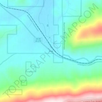
Nom : Carte topographique Page, altitude, relief.
Lieu : Page, LeFlore County, Oklahoma, United States (34.69066 -94.56967 34.73066 -94.52967)
Altitude moyenne : 388 m
Altitude minimum : 260 m
Altitude maximum : 765 m
Faire un don
Équipez-vous pour votre prochaine aventure :
En tant que Partenaire Amazon, ce site perçoit une commission sur les achats éligibles sans surcoût pour vous.
Autres cartes topographiques
Cliquez sur une carte pour visualiser sa topographie, son altitude et son relief.
Poteau
United States > Oklahoma > LeFlore County
The city is located in the valley below Cavanal Hill, dubbed the "World's Highest Hill" with a signed elevation of 1,999 feet (609 m). The location was a subject of extensive coal mining in the first half of the 20th Century, and a railway, eventually called the Poteau and Cavanal Mountain Railroad, served the…
Altitude moyenne : 189 m
Faire un don
Équipez-vous pour votre prochaine aventure :
En tant que Partenaire Amazon, ce site perçoit une commission sur les achats éligibles sans surcoût pour vous.
Poteau
United States > Oklahoma > LeFlore County
The city is located in the valley below Cavanal Hill, dubbed the "World's Highest Hill" with a signed elevation of 1,999 feet (609 m). The location was a subject of extensive coal mining in the first half of the 20th century, and a railway, eventually called the Poteau and Cavanal Mountain Railroad, served the…
Altitude moyenne : 189 m
Faire un don
Équipez-vous pour votre prochaine aventure :
En tant que Partenaire Amazon, ce site perçoit une commission sur les achats éligibles sans surcoût pour vous.
Poteau
United States > Oklahoma > LeFlore County
The city is located in the valley below Cavanal Hill, dubbed the "World's Highest Hill" with a signed elevation of 1,999 feet (609 m). The location was a subject of extensive coal mining in the first half of the 20th Century, and a railway, eventually called the Poteau and Cavanal Mountain Railroad, served the…
Altitude moyenne : 189 m