
Faire un don
Équipez-vous pour votre prochaine aventure :
En tant que Partenaire Amazon, ce site perçoit une commission sur les achats éligibles sans surcoût pour vous.
Carte topographique Mount Rushmore National Memorial
Cliquez sur la carte pour afficher l’altitude.
Faire un don
Équipez-vous pour votre prochaine aventure :
En tant que Partenaire Amazon, ce site perçoit une commission sur les achats éligibles sans surcoût pour vous.
Mount Rushmore National Memorial
Mount Rushmore National Memorial is a national memorial centered on a colossal sculpture carved into the granite face of Mount Rushmore (Lakota: Tȟuŋkášila Šákpe, or Six Grandfathers) in the Black Hills near Keystone, South Dakota, United States. Sculptor Gutzon Borglum created the sculpture's design and oversaw the project's execution from 1927 to 1941 with the help of his son, Lincoln Borglum. The sculpture features the 60-foot-tall (18 m) heads of four United States Presidents recommended by Borglum: George Washington (1732–1799), Thomas Jefferson (1743–1826), Theodore Roosevelt (1858–1919) and Abraham Lincoln (1809–1865). The four presidents were chosen to represent the nation's birth, growth, development and preservation, respectively. The memorial park covers 1,278 acres (2.00 sq mi; 5.17 km2) and the mountain itself has an elevation of 5,725 feet (1,745 m) above sea level.
Faire un don
Équipez-vous pour votre prochaine aventure :
En tant que Partenaire Amazon, ce site perçoit une commission sur les achats éligibles sans surcoût pour vous.
À propos de cette carte
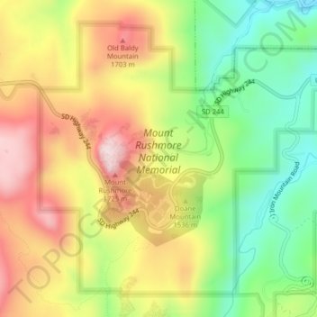
Nom : Carte topographique Mount Rushmore National Memorial, altitude, relief.
Altitude moyenne : 1 528 m
Altitude minimum : 1 343 m
Altitude maximum : 1 726 m
Faire un don
Équipez-vous pour votre prochaine aventure :
En tant que Partenaire Amazon, ce site perçoit une commission sur les achats éligibles sans surcoût pour vous.
Autres cartes topographiques
Cliquez sur une carte pour visualiser sa topographie, son altitude et son relief.
Black Hills
United States > South Dakota > Pennington County
The Black Hills is an isolated mountain range rising from the Great Plains of North America in western South Dakota and extending into Wyoming, United States. Black Elk Peak, which rises to 7,242 feet (2,207 m), is the range's highest summit. The name of the range in Lakota is Pahá Sápa. It encompasses the…
Altitude moyenne : 1 894 m
Pactola Reservoir Recreation Area
United States > South Dakota > Pennington County
Altitude moyenne : 1 491 m
Faire un don
Équipez-vous pour votre prochaine aventure :
En tant que Partenaire Amazon, ce site perçoit une commission sur les achats éligibles sans surcoût pour vous.
Black Hills
United States > South Dakota > Pennington County
The Black Hills is an isolated mountain range rising from the Great Plains of North America in western South Dakota and extending into Wyoming, United States. Black Elk Peak, which rises to 7,242 feet (2,207 m), is the range's highest summit. The name of the range in Lakota is Pahá Sápa. It encompasses the…
Altitude moyenne : 1 894 m
Black Elk Peak
United States > South Dakota > Pennington County
In September 2016, a team of professional surveyors obtained precise GNSS data over the course of two days and found the highest natural rock to be at 7,231.32 feet (2,204.11 m) NAVD88 and a nearby secondary peak located approximately 300 feet south of the lookout tower and unofficially named "McGillicuddy's…
Altitude moyenne : 1 923 m
Faire un don
Équipez-vous pour votre prochaine aventure :
En tant que Partenaire Amazon, ce site perçoit une commission sur les achats éligibles sans surcoût pour vous.
Mount Rushmore
United States > South Dakota > Pennington County
Mount Rushmore National Memorial is centered on a colossal sculpture carved into the granite face of Mount Rushmore (Lakota: Tȟuŋkášila Šákpe, or Six Grandfathers) in the Black Hills near Keystone, South Dakota. Sculptor Gutzon Borglum created the sculpture's design and oversaw the project's execution…
Altitude moyenne : 1 562 m
Black Hills
United States > South Dakota > Pennington County
The Black Hills is an isolated mountain range rising from the Great Plains of North America in western South Dakota and extending into Wyoming, United States. Black Elk Peak, which rises to 7,242 feet (2,207 m), is the range's highest summit. The name of the range in Lakota is Pahá Sápa. It encompasses the…
Altitude moyenne : 1 894 m
Faire un don
Équipez-vous pour votre prochaine aventure :
En tant que Partenaire Amazon, ce site perçoit une commission sur les achats éligibles sans surcoût pour vous.